
1. Introduction: The Global Challenge of Flash Floods
In my fifteen years architecting disaster mitigation systems, few environments present as many variables as the mountainous regions of India and South Korea. During monsoon and typhoon seasons, these landscapes transform into high-energy corridors where the “Flash Flood Challenge” manifests with lethal speed. The combination of complex natural river channels, extreme water velocity, and massive volumes of floating debris creates a hostile environment for any monitoring infrastructure.
Traditional submerged sensors often fail at the exact moment their data becomes most critical, falling victim to sediment burial or debris impact. To achieve hydrological resilience, non-contact radar technology is no longer a luxury—it is the definitive engineering choice. By decoupling the sensor from the medium, we ensure the continuous capture of water level and velocity data without the risk of equipment destruction.
2. The Strategy of Non-Contact Monitoring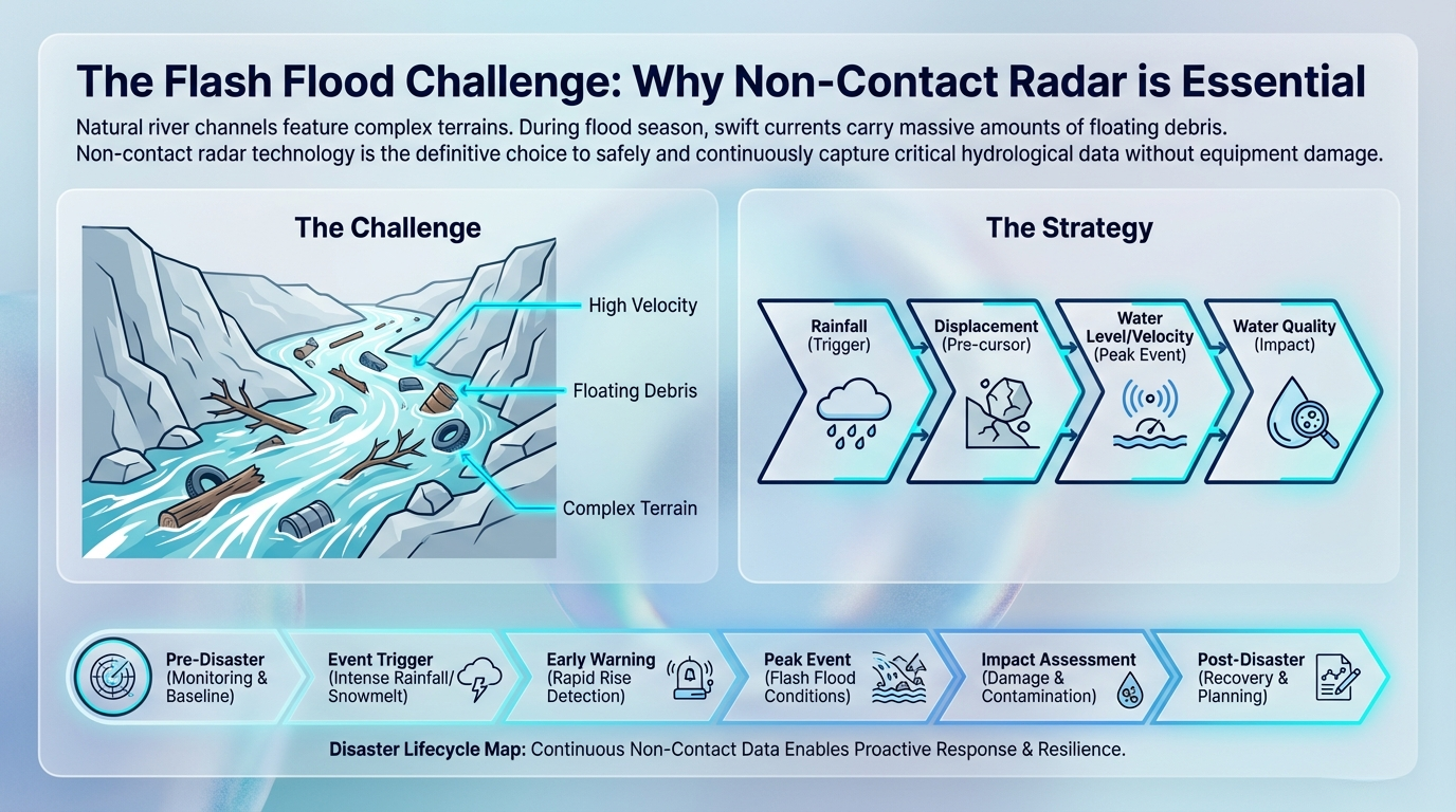
| Feature | Traditional Contact Sensors | Non-Contact Radar Sensors |
| Durability | High risk: Vulnerable to floating debris, sediment, and rocks. | Zero contact: Immune to physical debris damage. |
| Maintenance | High: Requires frequent cleaning of bio-fouling and silt. | Minimal: No submerged parts to clean or replace. |
| Safety | High risk: Personnel must access the water for maintenance. | Safe: Maintenance is performed from the bridge or bank. |
| Data Integrity | Prone to signal drift or loss during turbulent flow. | Stable: Reliable data regardless of surface turbulence. |
| Installation | Submerged: High complexity, requires water-entry. | Bridge-mount: Low complexity, safe overhead installation. |
To withstand the humidity and spray of a peak event, all core components adhere to the IP68 protection level, ensuring the system remains fully sealed and operational in extreme environmental conditions.
3. Core Technology: The 3-in-1 Radar “Command Node”
The primary intelligence hub of a modern hydrological station is the 3-in-1 radar sensor, specifically the RD-600/600S-01 or HD-RWLSFS-01. Rather than treating level and velocity as disparate data points, these units function as a command node that synthesizes data into a single, actionable vector.
The system calculates the volume of water moving through the channel using the following engineering logic: [Water Level] + [Surface Velocity] + [Cross-Section Area] = [Calculated Flow Rate]
Note: Achieving high-fidelity results with 3-in-1 sensors requires initial “cross-section profiling” to calibrate the area-velocity relationship.
Technical Specifications & Insights:
- Performance Range: Capable of a measuring range Up to 100m.
- Precision: High-level accuracy of +0.01m/s for velocity and +1%FS / ±2mm for water level.
- Simultaneous Monitoring: Tracks water level, surface velocity, and calculates total flow rate simultaneously from a single installation point.
- Direct Warning: Integrated alarms trigger automatically when critical thresholds are breached, providing immediate rapid-rise detection.
- Streamlined Deployment: Best overall value for complete sites, replacing multiple single-function sensors with one integrated unit to reduce site footprint.
4. Precision Components for Peak Event Tracking
In scenarios involving deep reservoirs, steep banks, or exceptionally wide rivers, dedicated radar components offer specialized performance.
Velocity Radar (RD-200-01 / HD-RWS25-01)
Best for wide, fast-moving rivers where flow speed is the primary concern. These sensors capture peak flood velocity unaffected by temperature or water friction.
- Accuracy: \pm 0.01m/s.
- Range: 0.03 \sim 20m/s (RD series) to 0.1 \sim 30m/s (HD series).
- Beam Angle: Targeted 12^\circ (RD) or 12^\circ \times 25^\circ (HD) configurations.
Water Level Radar (RD-300/RD-300S/HD-RWLP654)
For tracking the rise of the flood with millimeter precision, we deploy radars across three specific frequency tiers to maximize signal clarity:
- Bottom Level (Short Range): The RD-300S-01 utilizes 60GHz frequency for a 0.01 \sim 7.0m range with \pm 2mm accuracy.
- Middle Level (Mid Range): The RD-300-01 operates at 24GHz, covering 0.01 \sim 40.0m with \pm 3mm accuracy.
- Top Level (Ultra Range): The HD-RWLP654-01 is the pinnacle of the range, using 76-81GHz frequency to cover 0 \sim 65m (customizable beyond 65m) with \pm 1mm accuracy.
5. Managing the Full Disaster Lifecycle
A strategic hydrological solution must narrate the entire lifecycle of a disaster. Consider a typical monsoon event in the Western Ghats of India or a sudden mountain storm in South Korea:
Stage 1: Trigger (Precipitation Monitoring) As the storm clouds gather, the system begins at the Trigger phase. We analyze the rainfall-runoff relationship using the HD-PR-100 Piezoelectric sensor, which uses a maintenance-free solid-state design to calculate rainfall via raindrop impact. Simultaneously, the RD-RG-S Tipping Bucket provides \pm 3\% accuracy for historical tracking, allowing us to predict river rise hours before it begins.
Stage 2: Pre-cursor (Geological Warning) In complex terrains, intense rainfall often triggers landslides before the river peaks. The RD-DWD-01 Draw Wire Displacement Sensor acts as a geological sentry. With a range of 100mm to 35,000mm and a linear accuracy of \pm 0.25\% Full Scale, it detects micro-movements in the earth, alerting authorities to slope instability long before a catastrophic failure.
Stage 3: Peak Event (Hydrological Tracking) When the flood reaches its zenith, the radar sensors described in Section 4 take command. They provide a continuous, non-contact stream of data on velocity and height, ensuring that even as the river carries debris and moves at high speeds, the early warning system remains stable and data-rich.
Stage 4: Post-Flood (Ecological Assessment) Once the peak passes, the focus shifts to watershed recovery. We evaluate the ecological load by calculating Pollutant Flux: [Radar Flow Volume] \times [Sensor Concentration] = [Pollutant Flux] Using electrochemical pH sensors (\pm 0.02pH), optical Dissolved Oxygen sensors (\pm 0.5\%FS), and 90-degree light scattering Turbidity sensors (\pm 3\%FS), we can trace pollution sources and assess the environmental impact of the sediment and debris washed into the river.
6. The Ecosystem: Data Collection and Cloud Integration
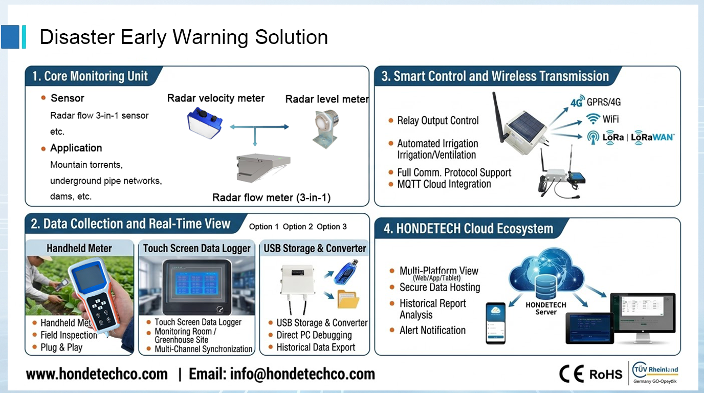
- Transmission Protocols: Systems support 4G/GPRS, WiFi, and LoRa/LoRaWAN, ensuring data transmission even from deep mountainous valleys.
- Cloud Integration: Full MQTT Cloud integration allows for secure data hosting and automated relay output control for downstream irrigation or safety systems.
- User Interface: Decision-makers access the Honde Cloud Ecosystem via Web, App, or Tablet for real-time alerts, historical report analysis, and field inspections using handheld meters.
7. Conclusion: Empowering Hydrological Resilience
Integrating advanced non-contact radar technology transforms disaster response from a reactive struggle into a proactive, data-driven strategy. By employing high-precision sensors capable of surviving the harshest environments, we provide the intelligence necessary to protect vulnerable communities in complex terrains.
Our mission remains: Empowering Hydrology with Technology & Data.
Honde Technology Co., Ltd.
Website: www.hondetechco.com
Email: info@hondetech.com
info@hondetechco.com
Post time: Mar-18-2026