
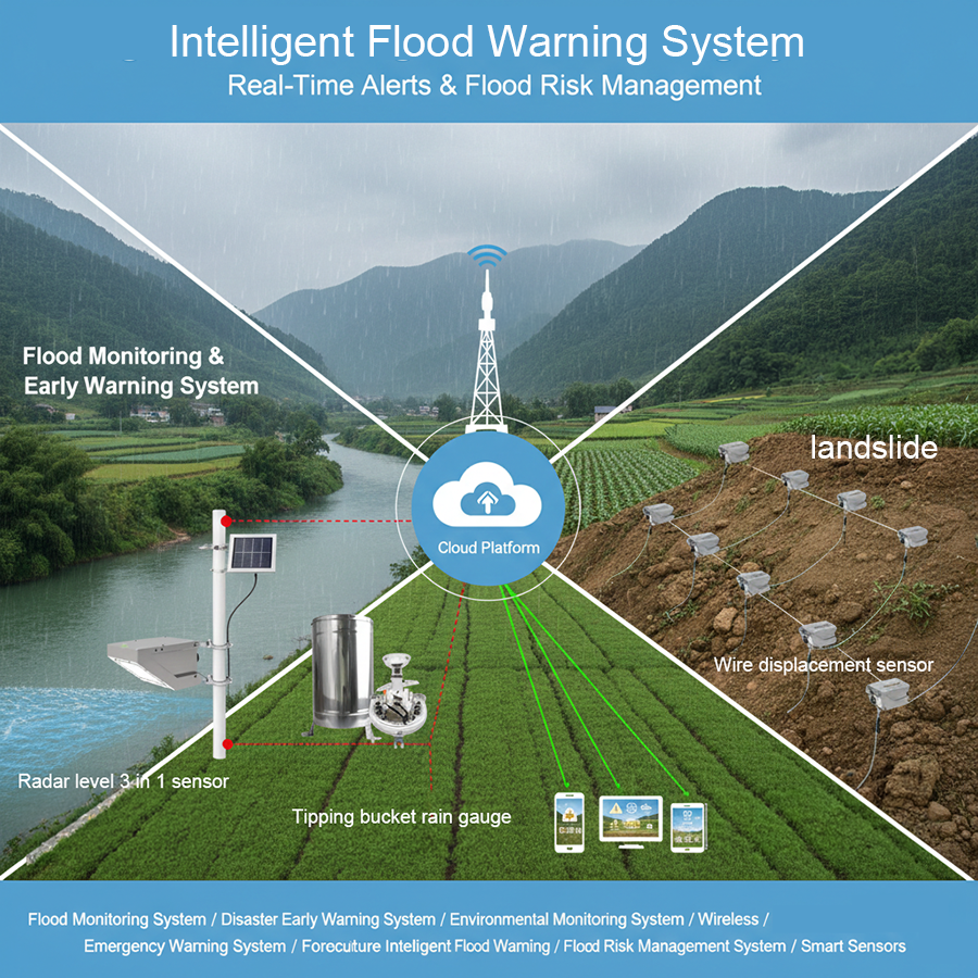
A modern Flood Monitoring system functions as a multi-layered IoT ecosystem that integrates Smart Sensors with a centralized Disaster Early Warning System to provide Real-Time Alerts. By leveraging 80GHz non-contact radar level sensors and precision rain gauges, the system establishes “full-domain perception” of hydrological conditions. This data is processed through a “rainfall-geology-hydrology” fusion layer to predict Flash Flood Warning scenarios. The final output is a closed-loop framework—Monitoring, Analysis, Early Warning, and Disposal—designed to break the barriers of monitoring single disasters and provide differentiated guidance for public safety.
- Moving beyond reactive disaster relief to proactive DRR. Our latest guide explores the integration of high-precision hydrological monitoring and multi-source data fusion to mitigate compound disaster risks.
- See the flood BEFORE it happens. From 80GHz radar tech to smart “bird-proof” rain gauges—this is the IoT hardware saving lives today.
- Technical Specifications for 80GHz Radar Sensors, Multi-source Data Correlation for Compound Disasters, and Hydrological Data Fusion Architecture.
1. The Core Sensing Layer
In disaster risk reduction, the margin between safety and catastrophe is measured in millimeters. The following sensing parameters represent the current industrial standard for resilient hydrological infrastructure.
|
Equipment Type
|
Technical Specifications
|
Measurement Method
|
Materials & Construction
|
|---|---|---|---|
|
Radar Level Sensor
|
Range: 7m; Frequency: 80GHz; Accuracy: ±1mm / ±2mm; Power: 7-32V DC
|
Non-contact (Pole-mounted)
|
IP68; Aluminum alloy shell; 4-20mA Analog output
|
|
Tipping Bucket Rain Gauge
|
Resolution: 0.2mm; Capacity: ≤ 4mm/min; Accuracy: ± 2% (≤ 1mm/min)
|
Mechanical Tipping Bucket
|
Stainless steel (Body/Base); Oblique outer blade mouth (splash prevention)
|
|
Draw Wire Displacement Sensor
|
Range: 100mm–35,000mm; Linear Accuracy: ±0.25% FS; Repeatability: ±0.05% FS
|
Contact (Wire extension)
|
SUS304 Stainless Steel wire (0.8mm/1.5mm); -10°C to 85°C
|
2.The Critical Role of Wireless Transmission
• Multi-Protocol Versatility: Integration of LoRa/LoRaWAN (EU868/915MHz), GPRS, 4G, and WiFi ensures that sensors can be deployed in deep valleys or high-altitude mountain torrent areas.
• Power Efficiency: Systems are designed for 7-32V DC operation, typically paired with solar panels and GPRS low-power measurement terminals to ensure 24/7 uptime without manual intervention.
• Global Interconnection: Utilizing the Beidou Satellite system provides a fail-safe channel for data transmission when terrestrial cellular networks are compromised during a disaster event.
3. The Four-Stage “Closed Loop” Logic
An expert-level system does not simply collect data; it establishes a “Closed Loop” of disaster prevention.
- Monitoring (Full-Domain Perception): The sensing layer establishes a multi-station network. This includes integrated rainfall stations, water level stations, and deep displacement monitoring stations to ensure no blind spots in the hydrological profile.
- Analysis (Hydrological Data Fusion): Data is ingested into a “rainfall-geology-hydrology” correlation database. Here, cloud computing models calculate the quantitative relationship between rainfall intensity, slope displacement rates, and the resulting river water level increases.
- Early Warning (Differentiated Guidance): The system breaks the silos of monitoring single disasters. When thresholds are breached, it issues hierarchical alerts tailored to specific stakeholders—government agencies receive logistical data, while the public receives evacuation instructions.
- Disposal (Coordinated Response): The final stage facilitates the response through LED large screens, emergency sirens, and smartphone integration, ensuring that the warning results in concrete “disaster prevention guidance.”
4. Strategic Application: Agricultural Disaster Prevention
5. Infrastructure & Data Connectivity
- Public Safety: Emergency broadcasting systems and LED large screens for community awareness.
- Operational Control: Provincial and City Monitoring Center Servers providing deep-dive PC-based analysis.
- Mobile Field Units: Real-time data and alarms pushed to tablets and smartphones for first responders and agricultural managers.
6. Conclusion & Expert Recommendation (CTA)
For more sensors information,
please contact Honde Technology Co., LTD.
WhatsApp: +86-15210548582
Email: info@hondetech.com
Company website: www.hondetechco.com
Post time: Jan-23-2026