

TL;DR
- In river gauging, dam forebay safety, and urban drainage networks, instrument engineers spend up to 3 hours per site configuring serial baud rates, setting mounting offsets, and troubleshooting external RTUs in harsh field weather.
- The global radar level transmitter and water sensor market is expanding toward $1.18 billion by 2034 (7.2% to 7.6% CAGR) , driven by demand for cellular IoT plug-and-play hydrological stations.
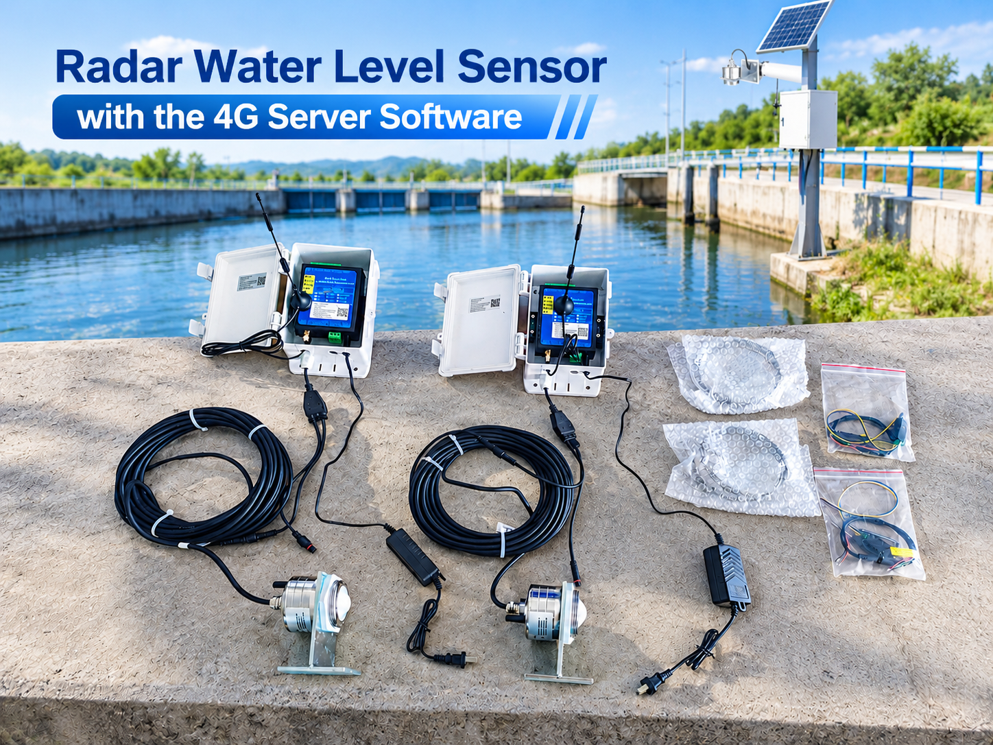
- Honde’s newly demonstrated Radar Water Level Sensor with 4G Server & Software System integrates an onboard leveling bubble, built-in Bluetooth smartphone calibration, a push-to-eject 4G SIM slot, and automatic APN matching.
- An engineer calibrates installation height (
H0) on an iOS/Android mobile app via Bluetooth, clicks the yellow button to insert a local 4G SIM card, powers the unit via 12V DC or a solar skid, and immediately streams real-time stage data into Honde Cloud Server Software without code or manual polling.
1.The Field Engineering Bottleneck: Why Remote Station Commissioning Costs Too Much
Across remote mountain catchments in Southeast Asia, reservoir dams in the Americas, and flood control sluices in Europe, hydrologists and municipal EPC contractors face a recurring field challenge:
- Complex Serial Debugging in the Rain: Legacy radar level gauges require technicians to carry laptops, USB-to-RS485 converters, and screwdrivers onto narrow bridge parapets to adjust Modbus registers.
- External RTU Wiring Frustrations: Wiring separate level sensors, standalone cellular modems, power regulators, and terminal blocks inside a weather cabinet introduces multiple points of loose-wire failure.
- Difficult Angle and Leveling Alignment: An unlevel radar sensor points off-nadir, scattering microwave reflections away from the receiver and causing phantom drift during high-water storm events.
- SIM Card Insertion & APN Roadblocks: Opening complex industrial modems to insert micro-SIM cards frequently damages seals or leads to telecommunication lockouts when APNs fail to match.
Field commissioning labor, vehicle travel time, and revisit truck-rolls often exceed the original purchase cost of the sensor itself.
2.Inside the Honde Video Demonstration: The 12-Minute Cloud Setup
In the engineering demonstration presented by Honde Technology engineer Marvin (YouTube Video Walkthrough: 4064, Radar Water Level Sensor with 4G Server Software), the manufacturer breaks down the complete physical unboxing, app-based calibration, and 4G cloud onboarding process:
Step 1: Physical Leveling and Zero-Angle Verification
The sensor bracket features an integrated circular spirit leveling bubble. Technicians mount the sensor crossbar parallel to the ground water plane, adjusting the bracket until the air bubble sits dead-center in the indicator circle, guaranteeing perpendicular microwave transmission.
Step 2: Smartphone Bluetooth App Parameter Setting
No laptops or field terminal software are required. The radar unit houses an integrated Bluetooth antenna. Technicians open the companion mobile app, pair with the sensor wirelessly via Bluetooth, input the measured installation height ( H0 distance from sensor face to riverbed), and calibrate offsets. The internal radar processor computes real-time absolute water stage automatically.
Step 3: Push-to-Eject 4G SIM Insertion & Auto-APN
The accompanying 4G industrial wireless module features an external yellow quick-release button. Pressing the button ejects the SIM card tray immediately. Technicians insert a standard local 4G SIM card (pre-configured to the carrier APN provided to Honde), push the tray back into place, and attach the high-gain omnidirectional 4G whip antenna.
Step 4: Power On and Cloud Stream Activation
The system connects via the provided 12V DC power adapter (or directly into an off-grid solar panel and battery system). The sensor cable attaches to the wireless module via heavy-duty industrial aviation connectors (dual-port design with reserved expansion). Once powered, the unit establishes cellular handshake automatically, pushing live stage curves to the Honde Cloud Server Software.
3.Technical Specifications: Honde 4G Radar Water Level Monitoring Node
| Parameter Category | Technical Specification |
|---|---|
| Model | Honde Radar Water Level Sensor with 4G Wireless Module System |
| Measurement Technology | High-frequency millimeter-wave FMCW radar |
| Measuring Range | Standard 0 to 40 meters / 65 meters (customizable up to 70m+) |
| Measurement Accuracy | ±1 mm to ±2 mm; Resolution: 1 mm |
| Beam Angle | Narrow 6° directional emission cone (minimizes bank/abutment clutter) |
| Local Calibration Method | Built-in Bluetooth with companion iOS / Android smartphone App |
| Leveling Aid | Integrated mechanical circular spirit level bubble |
| Wireless Telemetry | High-speed 4G LTE wireless transmission module (GPRS, LoRa/LoRaWAN optional) |
| SIM Interface | Push-button spring-loaded quick eject SIM card slot |
| Cloud Software & Server | Free Honde Cloud Server & PC/Mobile Software included |
| Data Protocols | Standard RS485 Modbus-RTU, MQTT JSON cloud streaming |
| Operating Voltage | DC 7–32 V (solar skid and battery storage compatible) |
| Protection Rating | IP68 fully submersible sensor housing; outdoor weatherproof RTU enclosure |
| Operating Temperature | -30 °C to +75 °C |
Country Demand Analysis: Where Fast-Deploy 4G Radar Telemetry Is Sourced
| Country / Region | Primary Hydrological Driver | Typical Deployment Environment | Preferred Sourcing Profile |
|---|---|---|---|
| Philippines | Tropical cyclone rainstorms, flash flood alerts (PAGASA, DPWH, MMDA networks) | River bridge cantilevers, Marikina/Laguna Lake basins, urban drainage pumping stations | 4G cellular telemetry, narrow 6° beam, solar-powered off-grid packages |
| United States | USGS hydrological gauging, dam spillway forebay monitoring, highway culvert safety | Remote mountain creeks, rural reservoir dams, stormwater detention ponds | High accuracy (±1mm), RS485 Modbus + MQTT JSON, cloud alert relays |
| Vietnam & Southeast Asia | MONRE automated river basin telemetry, industrial park drainage outfall compliance | Mekong & Red River tributaries, coastal sluice gates, aquaculture canals | Push-button SIM convenience, plug-and-play cloud dashboards, low maintenance |
| Australia | Regional catchment flood warning networks, mining tailings dam freeboard tracking | Unmanned outback river crossings, agricultural irrigation channels | Solar compatibility, extreme heat/UV durability, automated siren alarm relays |
4.Three Turnkey Deployment Solutions
To provide complete telemetry flexibility across municipal flood brigades, field inspections, and regional SCADA integration, Honde provides three standard hardware architectures:
1. Handmeter, Data logger with screen
Designed for mobile hydrological survey teams, field engineers, and seasonal calibration patrols. The Handmeter, Data logger with screen connects directly to the radar sensor via RS485/USB, powers the probe, displays live millimeter-accurate water level and temperature curves on an outdoor LCD, and logs historical readings into internal flash storage. Field inspectors can verify bridge elevations and export CSV/Excel records without bringing a laptop to slippery riverbanks.
2. GPRS/4G/WIFI/LORA/LORAWAN wireless module supports MQTT Json format
Demonstrated directly in the YouTube unboxing video. The GPRS/4G/WIFI/LORA/LORAWAN wireless module houses the push-eject SIM slot and cellular modem. It samples the radar sensor’s digital registers and transmits data packets in standardized MQTT Json format. This lightweight, open protocol drops directly into government civil defense mapping servers, municipal SCADA systems, or third-party IoT clouds without custom translation drivers.
3. Cloud server and software with alram relay system support to see the real time data, history data
The complete supervisory backend demonstrated in the video. The Cloud server and software with alram relay system support to see the real time data, history data visualizes real-time hydrographs, generates historical trend reports, and enables remote parameter tweaks. Crucially, the system features an automated alarm relay system: when river stage crosses user-defined Warning Stage or Flood Stage limits, the cloud server immediately trips a local physical relay to sound emergency sirens, close motorized floodgates, and dispatch urgent SMS/email notifications to crisis response personnel.
5.Real-World Case Study: 24-Station Remote Gauging Deployment in Rizal Province, Philippines
A regional disaster mitigation contractor required rapid deployment of 24 river gauging stations across tributary bridges feeding the Pasig-Marikina river system ahead of the peak typhoon season.
- The Challenge: The project had a tight 10-day commissioning window across rugged mountain terrain with intermittent rain. Traditional laptop-configured RTU stations averaged over 2.5 hours of setup time per bridge, threatening project deadlines.
- The Deployment: Engineers deployed 24 sets of the Honde Radar Water Level Sensor with 4G Server & Software System. Technicians leveled the sensor using the built-in spirit bubble, calibrated installation height within 3 minutes via the Bluetooth smartphone app, inserted local Globe/Smart 4G SIM cards into the push-eject tray, and connected solar skids.
- The Outcome: Average commissioning time dropped from 150 minutes to just 12 minutes per site. All 24 stations achieved 100% online cloud status within 3 business days. During Typhoon season downpours, the 80GHz FMCW radar maintained uninterrupted ±2mm stage tracking, and the cloud alarm relay automatically triggered downstream community sirens when mountain headwaters reached critical runoff velocity.
6.Commercial Value Comparison: Honde Bluetooth 4G Node vs. Traditional Serial RTU Stations
| Deployment Dimension | Honde Bluetooth App + 4G System | Conventional Third-Party RTU + Serial Radar |
|---|---|---|
| Field Setup Method | Wireless smartphone App via Bluetooth | Heavy laptop, serial drivers & USB converters |
| Mechanical Leveling | Integrated circular spirit level bubble | Requires external carpentry levels and shims |
| Cellular SIM Insertion | Quick yellow push-button eject tray | Complex enclosure disassembly & screw terminals |
| Cloud Software Cost | Free lifetime Honde Cloud Server & Software | Expensive third-party cloud subscription fees |
| Average Commissioning Time | ~12 minutes from box to live cloud data | 90 to 180 minutes of manual register mapping |
| Off-Grid Power Compatibility | Direct DC 7–32V (Solar battery ready) | Requires external DC-DC step-down converters |
7.Summary & Project Sourcing Next Steps
Deploying automated hydrological monitoring stations across remote rivers and reservoirs no longer requires cumbersome laptops, complicated register mapping, or specialized telecom technicians. By combining millimeter-wave radar precision with Bluetooth smartphone calibration, push-slot 4G telemetry, and free cloud server software, Honde delivers a truly turnkey solution for global flood defense and water resource management.
Honde Technology Co., Ltd. is a TÜV Rheinland verified manufacturer with standard orders shipping in 3–5 business days.
1.Handmeter, Data logger with screen; 2.GPRS/4G/WIFI/LORA/LORAWAN wireless module supports MQTT Json format; 3.Cloud server and software with alram relay system support to see the real time data, history data.
WhatsApp: +86-15210548582
Email: info@hondetech.com
Company Website: www.hondetechco.com
High-Volume & High-Conversion Keyword Strategy
Primary Keyword
- radar water level sensor with 4G server software
Secondary Keywords (High Search Volume)
- 4G wireless radar water level sensor
- non contact radar level transmitter RS485
- Bluetooth app radar level sensor
- remote river water level monitoring system
- cellular IoT radar water level gauge
Long-Tail Keywords (High Commercial Intent)
- radar water level sensor with 4G wireless RTU price
- solar powered 4G radar water level gauge for flood warning
- plug and play radar water level sensor MQTT JSON
- non contact river water level sensor with cloud alarm relay
- 80GHz radar water level transmitter with free software supplier
LSI & Semantic Vocabulary
- installation height calibration, built-in leveling bubble, Bluetooth app configuration
- push-to-eject SIM card slot, APN carrier matching, omnidirectional 4G antenna
- millimeter-wave FMCW radar, 6 degree beam angle, IP68 waterproof housing
- real-time hydrograph curve, historical water level logging, automated alarm relay system
Search Intent Matrix
| User Search Intent | Representative Keyword Query | Answering Article Module |
|---|---|---|
| Informational | “how to set up radar water level sensor with 4G cloud software” | Step-by-Step Video Walkthrough & Bluetooth Calibration |
| Commercial | “4G wireless radar level sensor vs traditional RTU stations” | Field Engineering Bottleneck & Comparison Table |
| Transactional | “radar water level sensor 4G software complete kit supplier price” | Specifications, Turnkey Solutions & Direct Contact Block |
On-Page SEO Elements
- H1: Unboxing and Field Commissioning: How Bluetooth App Setup and Push-Slot 4G Telemetry Cut Radar Water Level Station Deployment to 12 Minutes
- Meta Title: Radar Water Level Sensor with 4G Server Software | Honde Tech
- Meta Description: Unbox and deploy Honde’s radar water level sensor with 4G wireless telemetry and cloud server software. Bluetooth app setup, push-slot SIM, and automated cloud alarms.
- URL Slug:
/radar-water-level-sensor-4g-server-software - Image Alt Text:
Honde non-contact radar water level sensor with 4G wireless module, push-to-eject SIM card slot, and cloud server software
Post time: Oct-28-2026