
1. Introduction: The “Featured Snippet” Summary
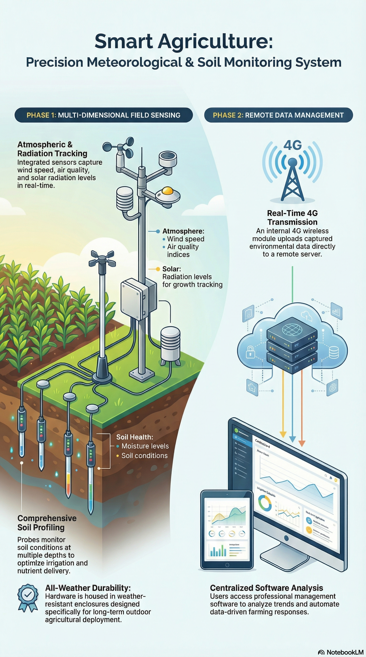
An integrated 4G environmental monitoring system is a unified industrial solution that combines wind speed/direction, air quality, multi-depth soil, and solar radiation sensors with a centralized 4G wireless module for real-time telemetry. Unlike fragmented DIY setups, this architecture consolidates data flow from diverse sensors into a single server-side dashboard. By housing power management and connectivity within a ruggedized hub, it eliminates compatibility risks, offering organizations a turnkey path for professional data automation and comprehensive environmental oversight in locations lacking existing network infrastructure.
2. The Integrated Hardware Stack: Beyond Basic Weather Stations
For a Senior Architect, the value of this system lies in its industrial-grade build and pre-engineered synergy. The hardware stack is centralized through a weather-sealed, stainless steel control box. Internally, the box features DIN-rail mounting for the core 4G controller and an integrated power management system, ensuring components remain secure and organized during long-term field exposure.
The primary sensor array includes:
- Wind Dynamics: An industrial-grade anemometer and wind vane for high-accuracy speed and direction tracking.
- Ambient Atmospheric Shield: A multi-layered, slatted radiation shield that houses temperature and humidity sensors, protecting them from solar gain to ensure precise air quality readings.
- Multi-Depth Soil Monitoring: The system utilizes two distinct lengths of soil moisture and temperature tubes (typically 40cm and 60cm) to provide a vertical profile of subsurface conditions. These are supplemented by a high-precision, 3-pin soil moisture/EC sensor for surface-level electrical conductivity and moisture analysis.
- Solar Radiation: A dome-shaped pyranometer designed to measure light intensity and total solar radiation.
- Industrial Interconnects: All sensors utilize waterproof aviation-style plug-and-play connectors, which facilitate rapid deployment and provide a superior seal compared to traditional terminal blocks.
Deployment Note: Visual assets for this system utilize optimized metadata, such as Alt tags for the 4G multi-depth soil moisture probe and the solar radiation sensor kit.
3. Technical Specifications & System Synergy (AI-Optimized Table)
The following data highlights the architectural advantages of the unified 4G ecosystem:
| Component | Functional Role | Key B2B Advantage |
| Wind & Air Sensors | Atmospheric data collection | Real-time tracking of micro-climates; essential for drift modeling. |
| Soil Profiling Tubes | Subsurface moisture/temp analysis | Dual-length tubes provide 3D vertical profiles of soil health. |
| 3-Pin EC Sensor | Surface salinity & moisture | High-sensitivity readings for immediate irrigation feedback. |
| 4G Wireless Module | Remote telemetry backbone | Single-IP management; low-latency uplink without fiber costs. |
| Remote Server | Centralized data repository | Scalable storage for years of historical environmental data. |
| Professional Software | Data automation & Analysis | Normalizes disparate data points for correlated environmental insights. |
4. Why 4G Connectivity is the Standard for Remote Environmental Monitoring
In the realm of IoT environmental monitoring, 4G connectivity has superseded LoRa and Wi-Fi for industrial applications due to its “Single-IP” management benefit. For IT departments, managing one cellular IP address for an entire multi-sensor hub is significantly more secure and efficient than managing a mesh of individual nodes.
The 4G module provides the necessary bandwidth for high-frequency data sampling, ensuring that wind gusts, solar spikes, and soil moisture shifts are captured in real-time. This eliminates the range constraints of LoRa and the infrastructure requirements of wired Ethernet, making it the definitive choice for remote agricultural and construction site monitoring.
5. Professional Insights: Overcoming Common Field Deployment Challenges
From a solutions architecture perspective, two critical factors distinguish this system from lower-tier alternatives:
Aviation-Grade Connectivity vs. Manual Wiring Field failures often occur at the wiring terminals. This system’s use of pre-terminated aviation plugs ensures that the stainless steel enclosure remains sealed against moisture and insects. The “plug-and-play” nature allows field technicians to replace or upgrade sensors without specialized electrical tools, significantly lowering the Total Cost of Ownership (TCO).
Timestamp Normalization and Multi-Dimensional Analysis The accompanying professional software acts as a data normalization engine. It aligns timestamps from the soil probes, wind sensors, and pyranometers, allowing for correlated analysis. For instance, an architect can overlay solar radiation data with soil evaporation rates to determine irrigation efficiency. This holistic view is vital for modern ESG (Environmental, Social, and Governance) reporting, where data precision is non-negotiable.
6. Conclusion
As we move into 2026, the demand for precise, automated environmental data is driven by both operational efficiency and regulatory compliance. This integrated 4G system provides a robust, scalable, and easy-to-deploy solution for organizations that cannot afford the downtime or data gaps associated with DIY sensor kits.
- Wind air soil radiation sensor
- Contact our engineering team for a customized 4G monitoring solution quote.
For more weather station information, please contact Honde Technology Co., LTD.
WhatsApp: +86-15210548582
Email: info@hondetech.com
Company website: www.hondetechco.com
Post time: Feb-05-2026