
Abstract
India is a country frequently affected by flash floods, particularly in the Himalayan regions of the north and northeast. Traditional disaster management methods, often focused on post-disaster response, have resulted in significant casualties and economic losses. In recent years, the Indian government has vigorously promoted the adoption of high-tech solutions for the early warning of flash floods. This case study, focusing on the severely affected Himachal Pradesh, details the application, effectiveness, and challenges of its integrated Flash Flood Warning System (FFWS), which combines radar flow meters, automatic rain gauges, and displacement sensors.
1. Project Background and Need
Himachal Pradesh’s topography is characterized by steep mountains and deep valleys, with a dense network of rivers. During the monsoon season (June-September), it is highly susceptible to short-duration, high-intensity rainfall triggered by the southwest monsoon, leading to devastating flash floods and landslides. The 2013 Kedarnath disaster in Uttarakhand, which killed thousands, served as a critical wake-up call. The traditional rain gauge network was sparse and data transmission was lagged, unable to meet the need for accurate monitoring and rapid warning of sudden, highly localized heavy rainfall.
Core Needs:
- Real-time Monitoring: Minutely data collection of rainfall and river water levels in remote, inaccessible watersheds.
- Accurate Prediction: Establish reliable rainfall-runoff models to predict the time of arrival and scale of flood peaks.
- Geological Hazard Risk Assessment: Evaluate the risk of slope instability and landslides triggered by heavy rainfall.
- Rapid Warning: Seamlessly deliver warning information to local authorities and communities to buy precious time for evacuation.
2. System Components and Technology Application
To address these needs, Himachal Pradesh collaborated with the Central Water Commission (CWC) and the India Meteorological Department (IMD) to deploy an advanced FFWS in its high-risk watersheds (e.g., Sutlej, Beas basins).
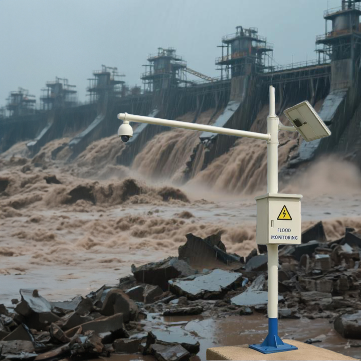
1. Automatic Rain Gauges (ARGs)
- Function: As the most front-line and fundamental sensing units, ARGs are responsible for collecting the most critical data: rainfall intensity and accumulated rainfall. This is the direct driving factor behind flash flood formation.
- Technical Features: Using a tipping bucket mechanism, they generate a signal for every 0.5mm or 1mm of rainfall, transmitting data in real-time to the control center via GSM/GPRS or satellite communication. They are strategically deployed in the upper, middle, and lower reaches of watersheds to form a dense monitoring network, capturing the spatial variability of rainfall.
- Role: Provide input data for model calculations. When an ARG records rainfall intensity exceeding a preset threshold (e.g., 20 mm per hour), the system automatically triggers an initial alert.
2. Non-Contact Radar Flow/Level Meters (Radar Water Level Sensors)
- Function: Installed on bridges or bankside structures, they measure the distance to the river surface without contact, thereby calculating the real-time water level. They provide a direct warning when water levels exceed danger marks.
- Technical Features:
- Advantage: Unlike traditional contact-based sensors, radar sensors are unaffected by impact from sediment and debris carried by floodwaters, requiring minimal maintenance and offering high reliability.
- Data Application: Real-time water level data, combined with upstream rainfall data, is used to calibrate and validate hydrological models. By analyzing the rate of water level rise, the system can more accurately predict the flood peak and its time of arrival for downstream areas.
- Role: Provide conclusive evidence that flooding is occurring. They are key for validating rainfall predictions and triggering emergency responses.
3. Displacement/Crack Sensors (Crack Meters & Inclinometers)
- Function: Monitor slopes at risk of landslides or debris flows for displacement and deformation. They are installed on known landslide bodies or high-risk slopes.
- Technical Features: These sensors measure the widening of surface cracks (crack meters) or subsurface soil movement (inclinometers). When the displacement rate exceeds a safe threshold, it indicates a rapid decline in slope stability and a high probability of a major slide under persistent rainfall.
- Role: Provide an independent assessment of geological hazard risk. Even if rainfall does not reach flood alert levels, a triggered displacement sensor will prompt a landslide/debris flow warning for a specific area, serving as a crucial supplement to pure flood warnings.
System Integration & Workflow:
Data from ARGs, radar sensors, and displacement sensors converge at a central warning platform. Built-in hydrological and geological hazard models perform integrated analysis:
- Rainfall data is input into models to predict potential runoff volume and water levels.
- Real-time radar water level data is compared against predictions to continuously correct and improve model accuracy.
- Displacement data serves as a parallel indicator for decision-making.
Once any data combination exceeds preset multi-level thresholds (Advisory, Watch, Warning), the system automatically disseminates alerts to local officials, emergency response teams, and community leaders via SMS, mobile apps, and sirens.
3. Outcomes and Impact
- Increased Lead Time: The system has increased critical warning lead times from nearly zero to 1-3 hours, making the evacuation of high-risk villages feasible.
- Reduced Loss of Life: During several heavy rainfall events in recent years, Himachal Pradesh has successfully executed multiple pre-emptive evacuations, effectively preventing major casualties. For instance, in the 2022 monsoon, the Mandi district evacuated over 2,000 people based on warnings; no lives were lost in the subsequent flash flood.
- Data-Driven Decision Making: Shifted the paradigm from reliance on experiential judgment to scientific and objective disaster management.
- Enhanced Public Awareness: The system’s presence and successful warning instances have significantly increased community awareness and trust in early warning information.
4. Challenges and Future Directions
- Maintenance and Cost: Sensors deployed in harsh environments require regular maintenance to ensure data continuity and accuracy, posing an ongoing challenge to local financial and technical capacity.
- “Last Mile” Communication: Ensuring warning messages reach every individual in every remote village, especially the elderly and children, requires further improvement (e.g., relying on radio, community bells, or gongs as backup).
- Model Optimization: India’s complex geography necessitates continuous data collection to localize and optimize prediction models for improved accuracy.
- Power and Connectivity: Stable power supply and cellular network coverage in remote areas remain problematic. Some stations rely on solar power and satellite communication, which are more expensive.
Future Directions: India plans to integrate more technologies, such as weather radar for more precise rainfall nowcasting, using Artificial Intelligence (AI) and Machine Learning to analyze historical data for optimized warning algorithms, and further expand the system’s coverage to other flash flood-prone states.
Conclusion
The flash flood warning system in Himachal Pradesh, India, is a model for developing countries using modern technology to combat natural disasters. By integrating automatic rain gauges, radar flow meters, and displacement sensors, the system creates a multi-layered monitoring network from “sky to ground,” enabling a paradigm shift from passive response to active warning for flash floods and their secondary hazards. Despite challenges, the proven value of this system in protecting lives and property offers a successful, replicable model for similar regions worldwide.
Complete set of servers and software wireless module, supports RS485 GPRS /4g/WIFI/LORA/LORAWAN
For more sensors information,
please contact Honde Technology Co., LTD.
Email: info@hondetech.com
Company website: www.hondetechco.com
Tel: +86-15210548582
Post time: Aug-27-2025