
1. Introduction: The Unique Challenges of Small and Medium River Basins
In my 15 years of designing environmental monitoring networks, I have found that small and medium-sized river basins are among the most difficult environments to manage. These systems are notoriously volatile; unlike large rivers that respond slowly to precipitation, small basins can transition from a steady state to a life-threatening flash flood in a matter of minutes.
Traditional contact-based measurement—relying on submerged pressure transducers or mechanical rotors—is fundamentally unsuited for these conditions. During a flood event, these basins exhibit high-velocity turbulent flows and carry significant concentrations of floating debris, timber, and sediment. Such conditions frequently lead to sensor drift, clogging, or the total destruction of submerged equipment exactly when data is most critical. Non-contact radar technology, specifically the RD-600 series, has emerged as the professional standard. By measuring from above the water surface, we eliminate physical risk to the hardware and ensure the reliability of the early warning “safety net.”
2. The Core Solution: Non-Contact Radar Flow Measurement
The RD-600 radar flowmeter utilizes a sophisticated Planar Microstrip Array Antenna employing CW + PCR (Continuous Wave and Pulse Coherent Radar) technology. This dual-approach allows for simultaneous, high-precision measurement of both surface velocity and water level without altering the hydraulic boundary conditions of the river or channel.
Methodology and Principles
- Velocity Measurement: The system uses the Doppler principle to capture surface velocity. A 24GHz signal is emitted (100mW standard power) at a 12° radio wave emission angle. The frequency shift of the return signal provides a real-time velocity reading.
- Velocity-Area Method: Measuring surface velocity is only the first step. To provide a true flow rate, the system integrates its water level data to calculate the cross-sectional area. The RD-600 is pre-programmed with empirical formulas for velocity distribution across various channel geometries, including circular, rectangular, and trapezoidal sections. This allows the internal hydraulic model to convert surface velocity into a calculated average velocity for the entire section.
- Field-Hardened Features: From an engineering perspective, the RD-600’s automatic recognition of water flow direction and built-in vertical angle correction are indispensable. These features mitigate common installation errors in rugged terrain, ensuring data integrity even when mounting conditions are less than ideal.
Benefits of the Non-Contact Approach:
- Infrastructure Safety: Suspended above the water, the sensor is immune to flood-borne debris and high-velocity “flood peak” impacts.
- Hydraulic Integrity: No obstruction is placed in the water, preventing any change to the flow characteristics or the accumulation of trash.
- Operational Efficiency: The system operates at an ultra-low 3.5~4.35VDC range. For the remote, solar-powered stations I often design, this low power consumption is a decisive factor for 24/7 reliability.
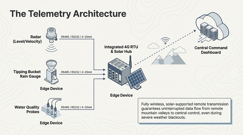
3. Essential Components of a Hydro-Meteorological Warning System
A robust early warning system is more than a single sensor; it is a synchronized hardware suite designed to capture the “Rainfall-Runoff” (降雨-径流) relationship.
- Radar Velocity Sensor: Operating at 24GHz, this sensor captures flood peak velocity (洪峰流速) within a range of 0.03 to 20m/s. Its accuracy of ±0.01m/s and ±1%FS ensures that even the most subtle changes in flow are recorded.
- Radar Water Level Sensor: Utilizing a 60GHz frequency with a narrow 8° antenna angle (10mW power), this sensor provides a 40-meter measuring range with ±2mm accuracy. This level of precision is the bedrock of any flash flood warning.
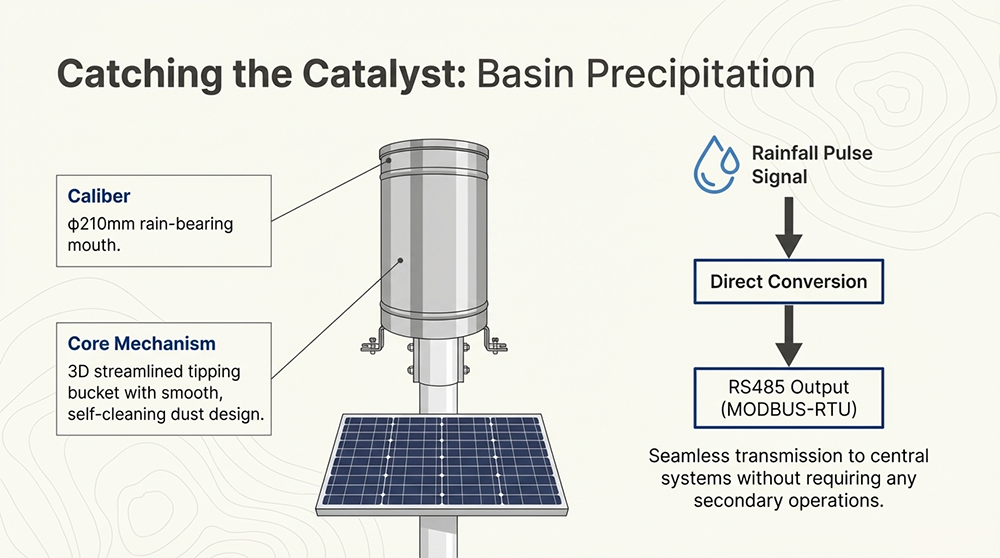
- Rainfall Sensors (Tipping Bucket): We utilize a stainless steel digital tipping bucket with a 210mm caliber. Its 3D streamlined design is specifically engineered for self-cleaning and dust resistance, outputting data via standard MODBUS-RTU protocol.
- Predictive Analysis: By integrating precipitation data with real-time flow, we can analyze the Rainfall-Runoff relationship. This involves calculating the “lag time” between a rainfall event and the arrival of the flood peak. By understanding antecedent moisture and rainfall intensity, the system predicts critical thresholds, providing authorities with a larger window for evacuation and emergency response.
4. Expanding the Scope: Ecological Load and Pollutant Flux
Modern river management has evolved beyond disaster prevention; we are now equally focused on ecological safety. By integrating Multi-parameter Water Quality Sensors, we can monitor the chemical health of the basin alongside its physical flow.
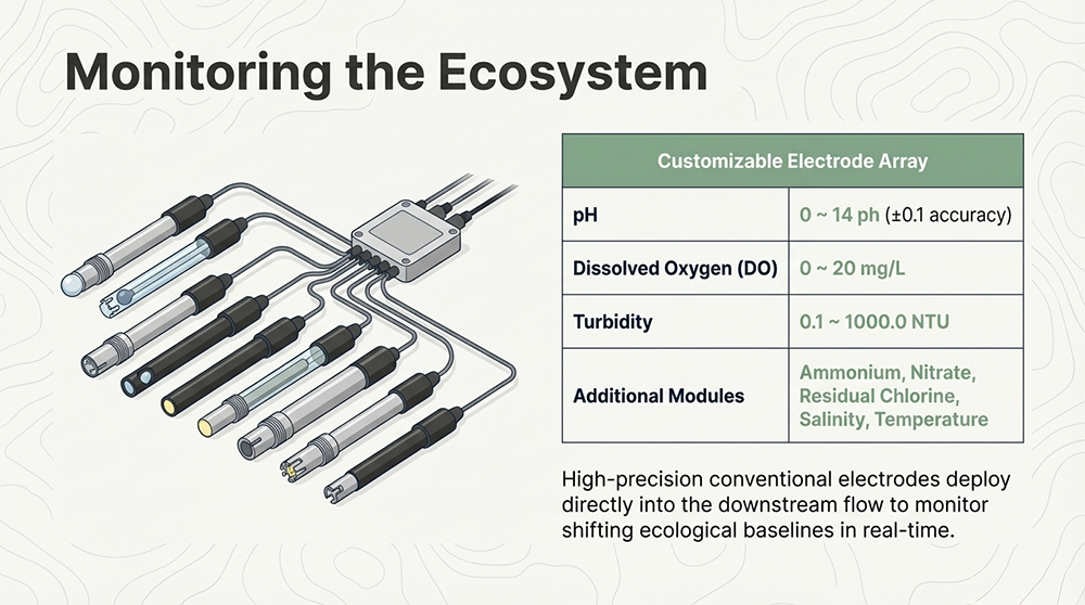
High-Precision Water Quality Parameters
| Parameter | Measurement Range | Resolution | Accuracy |
| PH | 0 ~ 14 ph | 0.01 ph | ±0.1 ph |
| Turbidity | 0.1 ~ 1000.0 NTU | 0.1 NTU | ±3% FS |
| Dissolved Oxygen (DO) | 0 ~ 20 mg/L | 0.01 mg/L | ±0.6 mg/L |
| Conductivity (EC) | 0 ~ 10000 uS/cm | 1 uS/cm | ±1% FS |
| Ammonium | 0.1 ~ 18000 ppm | 0.01 PPM | ±0.5% FS |
| COD | Customizable | High-Precision | Per Specification |
| Nitrate | 0.1 ~ 18000 ppm | 0.01 PPM | ±0.5% FS |
| Temperature | 0 ~ 60°C | 0.1°C | ±0.5°C |
The “Flux” Equation and Synchronization The true value of this integration is the calculation of Pollutant Flux:
Flow Rate (from Radar) × Concentration (from Water Quality Sensor) = Pollutant Flux
The integrated 4G RTU acts as the system’s brain, ensuring that the timestamp of the flow data perfectly aligns with the concentration data. This temporal synchronization allows environmental bureaus to calculate the total mass of a pollutant moving through a cross-section, which is essential for assessing ecological load and tracing illegal discharge sources with mathematical precision.
5. Technical Specifications and System Robustness
To withstand the rigors of field deployment, the system is designed with high-grade industrial protections:
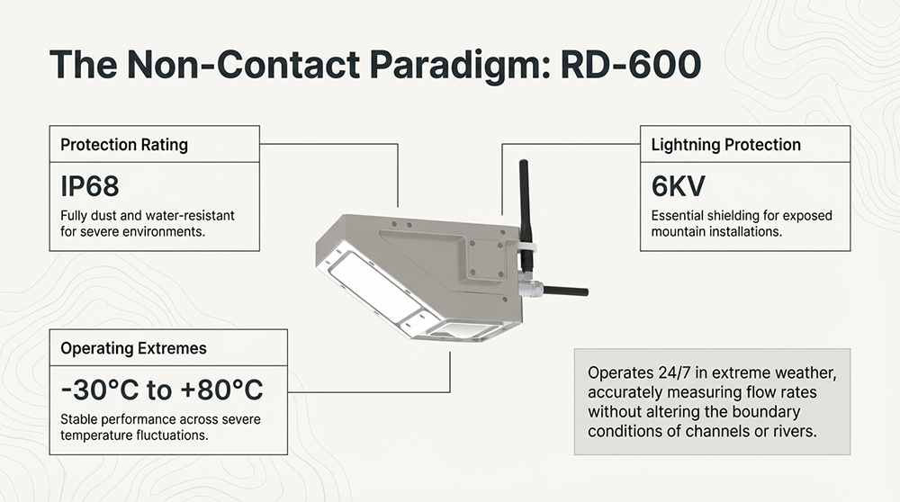
- Environmental Resilience: Full functionality is maintained 24/7, including heavy rain, from -30°C to +80°C.
- Physical Durability: The hardware carries an IP68 protection rating and features 6KV lightning protection, shielding sensitive electronics from the electrical surges common during severe storms.
- Connectivity: Data is transmitted via RS485 (MODBUS-RTU), RS232, or 4~20mA. The optional integrated 4G RTU provides a seamless telemetry solution for remote river stretches where wired infrastructure is non-existent.
6. Conclusion: A Data-Driven Approach to River Management
Integrating non-contact radar flow measurement with rainfall and water quality sensing creates a comprehensive “safety net” for the modern age. By replacing vulnerable contact sensors with robust CW + PCR radar technology, we eliminate the blind spots that traditionally occur during the most dangerous phases of a flood. This data-driven approach provides the high-fidelity insights required for both emergency disaster mitigation and long-term ecological stewardship of our vital water resources.
For more sensor information,
please contact Honde Technology Co., LTD.
WhatsApp: +86-15210548582
Email: info@hondetech.com
Company website: www.hondetechco.com
Post time: Mar-17-2026