
The Mountain Torrent Monitoring System is a comprehensive early warning platform that integrates modern sensing technology, communication technology, and data analysis. Its core purpose is to enable accurate prediction, timely warning, and rapid response to mountain flood disasters by capturing key hydrometeorological data in real time, thereby maximizing the protection of people’s lives and property.
Complete set of servers and software wireless module, supports RS485 GPRS /4g/WIFI/LORA/LORAWAN
For more water sensor information,
please contact Honde Technology Co., LTD.
Email: info@hondetech.com
Company website: www.hondetechco.com
Tel: +86-15210548582
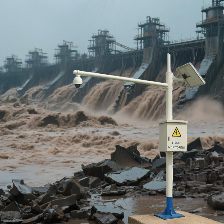
The system relies on a network of intelligent monitoring devices deployed at the field level. Among them, the 3-in-1 Hydrological Radar and Rain Gauge play vital roles.
I. Core Monitoring Equipment and Their Functions
1. 3-in-1 Hydrological Radar (Integrated Hydrological Radar Sensor)
This is an advanced non-contact monitoring device that typically integrates three functions into one unit: millimeter-wave radar flow measurement, video surveillance, and water level radar. It serves as the “cutting edge” of modern mountain torrent monitoring.
- Role of Millimeter-Wave Radar Flow Measurement:
- Principle: It transmits electromagnetic waves towards the water surface and calculates the surface velocity of the flow by receiving waves reflected from floating debris or small ripples using the Doppler effect.
- Advantages: Long-range, high-precision measurement without the need for structures to be built in the river channel. It is unaffected by sediment or floating debris, offering significant safety advantages, especially in steep, treacherous mountain rivers where water levels rise and fall rapidly.
- Role of Video Surveillance:
- Visual Verification: Provides live video feed of the site, allowing command center personnel to visually assess river flow conditions, water levels, the surrounding environment, and whether people are present, thereby verifying the radar data accuracy.
- Process Recording: Automatically records or captures images of the entire flood event, providing valuable footage for post-disaster assessment and scientific research.
- Role of Water Level Radar:
- Precise Ranging: Measures the distance to the water surface by transmitting radar waves and calculating their time of return, enabling accurate, continuous measurement of water level elevation unaffected by temperature, fog, or surface debris.
- Core Parameter: Water level data is a critical parameter for calculating flow rate and determining flood severity.
【Integrated Value of the 3-in-1 Unit】: A single device simultaneously captures three key pieces of information—flow velocity, water level, and video. This enables cross-verification of data and visuals, greatly enhancing the reliability of monitoring data and the accuracy of warnings, while also reducing construction and maintenance costs.
2. Rain Gauge (Tipping Bucket Rain Gauge)
Rainfall is the most direct and forward-looking driver of mountain torrents. Automatic rain gauges are fundamental and critical devices for monitoring precipitation.
- Monitoring Role:
- Real-time Rainfall Monitoring: Measures and records rainfall amount and rainfall intensity (amount of rain per unit of time, e.g., mm/hour) in real time.
- Core Input for Early Warning: Intense rainfall is the most direct trigger for mountain torrents. By analyzing these two key metrics—preceding cumulative rainfall and short-term rainfall intensity—in conjunction with models of soil saturation and terrain, the system can assess disaster risk and issue warnings. For example, “rainfall exceeding 50 mm within 1 hour” might trigger an orange warning.
II. System Synergy and Workflow
These devices do not operate in isolation but work together to form a complete monitoring and warning loop:
- Rainfall Monitoring (Initial Warning): The rain gauge is the first to detect high-intensity, short-duration heavy rainfall—this is the ”first alarm” for a mountain flood. The system platform calculates areal rainfall and performs an initial regional risk assessment, potentially issuing a preliminary warning to alert relevant areas.
- Hydrological Response Verification (Precise Warning): Rainfall converges into surface runoff, beginning to gather in river channels.
- The 3-in-1 Hydrological Radar detects rising water levels and increasing flow velocity.
- The video feed simultaneously returns live images showing increased flow in the river channel.
- This process verifies that the rainfall has produced an actual hydrological response, confirming that a mountain flood is forming or has occurred.
- Data Analysis and Decision Making: The monitoring platform feeds real-time rainfall, water level, and flow velocity data into a mountain flood forecasting model for rapid calculation and comprehensive analysis. This enables more accurate prediction of peak flow, time of arrival, and impact area.
- Warning Issuance: Based on the analysis results, warnings of different levels (e.g., Blue, Yellow, Orange, Red) are issued to disaster response personnel and the public in at-risk areas through various channels such as broadcasts, text messages, sirens, and social media, guiding evacuation and避险 (bì xiǎn, risk avoidance).
Conclusion
- The Rain Gauge acts as the ”Early Warning Scout”, responsible for detecting the cause (heavy rain) of mountain torrents.
- The 3-in-1 Hydrological Radar acts as the ”Field Commander”, responsible for confirming the occurrence (water level, flow velocity) of the flood and providing field evidence (video).
- The Mountain Torrent Monitoring System Platform acts as the ”Intelligent Brain”, responsible for aggregating all information, performing analysis and decision-making, and ultimately issuing evacuation orders.
Post time: Aug-20-2025