

Flood monitoring is changing rapidly. As extreme rainfall, flash floods and urban drainage risks place greater pressure on communities and infrastructure, water authorities are looking for monitoring systems that can provide real-time water-level information without requiring personnel to enter dangerous flood environments.
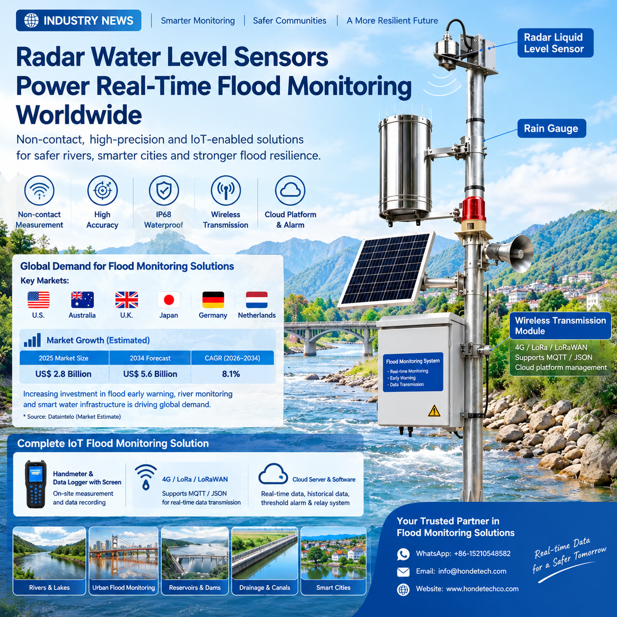
This is driving demand for radar water level sensors, non-contact river monitoring systems, IoT flood monitoring stations and cloud-based early warning platforms.
A 2026 market estimate places the global flood warning system market at approximately US$2.8 billion in 2025, with a projected value of US$5.6 billion by 2034, representing an estimated CAGR of 8.1%. Hardware accounted for about 42.3% of the market in 2025, while radar-based technology represented an estimated 28.4%. These figures are third-party market estimates rather than government statistics.
The opportunity is particularly relevant to countries with extensive river networks, flood-prone urban areas and established water-management infrastructure, including the United States, Australia, the United Kingdom, Japan, Germany and the Netherlands.
1. Why Real-Time Water-Level Monitoring Matters
During a major flood, water levels can change much faster than traditional manual inspection schedules.
A monitoring station that only provides occasional measurements may not give emergency teams enough information to understand how quickly a river is rising.
Modern flood monitoring therefore focuses on a continuous data chain:
This approach allows water authorities to see current conditions, review historical trends and identify rapid changes remotely. The value of this approach is particularly clear in Australia.
In August 2026, the Australian Bureau of Meteorology reported that a new water-level radar installed at Cairns Airport had restored critical flood monitoring on the Barron River after the previous station was damaged during Tropical Cyclone Jasper. The radar measures the river remotely from above the water surface and sends real-time data to the Bureau. Following the successful installation, nine additional sites were identified for implementation.
This is a strong real-world indication of where river monitoring technology is heading: more remote sensing, less exposure to dangerous water conditions and faster access to flood information.
2. Radar Technology Provides a Non-Contact Alternative
Traditional water-level instruments can be installed in or close to the water. During severe floods, however, sediment, debris, high flow velocity and changing river conditions can make maintenance more difficult.
✓ Key Product Specifications
| Parameter | Specification |
|---|---|
| Measurement Technology | 24 GHz FMCW Radar |
| Measurement Range | 0.01–40.0 m |
| Stated Accuracy | ±3 mm |
| Protection | IP68 |
| Operating Temperature | -35°C to +70°C |
| Power Supply | 7–32 VDC |
| Communication | RS485 / RS232 / 4–20mA |
| Wireless Options | 4G / LoRa / LoRaWAN |
| Typical Applications | Rivers / Reservoirs / Urban Flooding / Open Channels / Drainage |
The manufacturer states that the radar measurement is designed to reduce the influence of temperature, humidity, water vapor, sediment and floating objects, while the non-contact structure avoids direct corrosion from the water body.
3. Where Is Demand Growing?
The strongest opportunities are not limited to one type of flood. Radar water-level monitoring can support river flooding, flash flooding, reservoir management, urban drainage and open-channel monitoring.
| Market | Main Requirement | Potential Application |
|---|---|---|
| United States | Real-time flood data networks | Rivers, bridges, flood-prone roads |
| Australia | Remote river and flood-warning monitoring | Rivers, catchments, remote stations |
| United Kingdom | Surface-water and urban flood monitoring | Drainage, rivers, urban areas |
| Japan | Dense river and disaster-monitoring infrastructure | Rivers, reservoirs, urban drainage |
4. The UK Shows Why Urban Flood Monitoring Is Becoming More Important
The UK’s latest national flood-risk assessment identifies approximately 4.6 million properties at risk from surface-water flooding. This creates opportunities for compact water-level monitoring stations in:
5. Complete IoT Flood Monitoring Solution
1. Handmeter and Data Logger
For field engineers, a handheld meter and data logger can provide local measurement and data recording for on-site inspection and sensor commissioning.
2. Wireless Data Transmission
3. Cloud Server, Software and Alarm Relay
- Real-time water-level data
- Historical records
- Threshold alarms
- Relay control
High-Intent Keywords for Global Buyers
| Category | Keywords |
|---|---|
| Core Product | radar water level sensor, radar water level meter |
| Flood | flood monitoring sensor, real time flood monitoring system |
| Wireless | 4G water level monitoring system, LoRaWAN water level sensor |
Radar Water Level Monitoring Solution
Technology: 24 GHz FMCW Radar
Range: 0.01–40.0 m
Accuracy: ±3 mm
Protection: IP68
WhatsApp: +86-15210548582
Email: info@hondetech.com
Website: www.hondetechco.com
Company: Honde Technology Co., Ltd.
Post time: Oct-08-2026