

TL;DR
- In river basin flood defense, reservoir spillway management, and urban drainage networks, monitoring river stage alone creates a reactive 2-hour delay, while mechanical rain funnels frequently jam from bird nesting and airborne leaves.
- The global flood early warning and hydrological telemetry market is expanding toward $3.42 billion by 2034 (CAGR 6.1% to 7.4%) (Persistence Market Research), driven by municipal civil defense mandates requiring multi-sensor IoT linked stations.
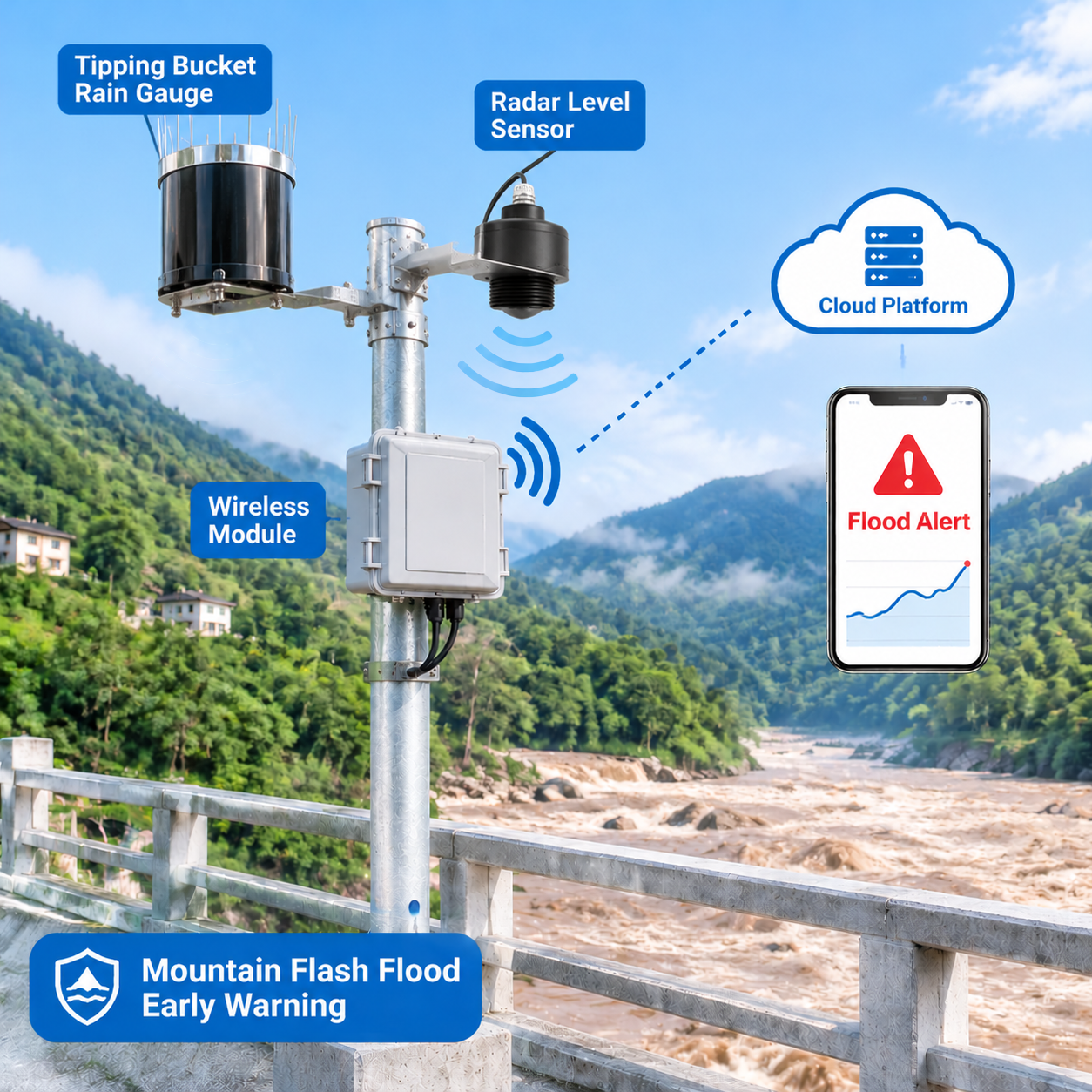
- Honde’s newly demonstrated Rain Gauge and Radar Water Level Monitoring System integrates an 80GHz FMCW non-contact radar level sensor (up to 40m/65m, ±1mm accuracy, narrow 6° beam) with a WMO-standard 0.2mm/0.5mm tipping bucket rain gauge featuring integrated stainless-steel bird-proof spikes and filtration mesh.
- Streaming over a multi-interface RTU gateway (4G LTE, WiFi, RJ45 Ethernet, and standard MQTT JSON telemetry), the system correlates upstream precipitation intensity with downstream river cresting in real time, triggering automated cloud alarm relays to sound evacuation sirens and close floodgates up to 4 to 6 hours before peak inundation.
1.The Hydrological Early Warning Bottleneck: Why Standalone Sensors Fail During Storms
Municipal disaster risk reduction agencies, dam dispatchers, and environmental protection contractors across Southeast Asia, North America, and Europe face an operational disconnect during extreme convective storm events:
- The Downstream Stage-Only Lag: Relying exclusively on downstream river gauges creates a dangerous blind spot. By the time an in-stream sensor registers a rapid rise at an urban bridge, mountain headwaters have already discharged millions of cubic meters of runoff hours earlier.
- Bird Nesting & Funnel Clogging: In outdoor meteorological stations, birds perch on open rain funnels, dropping twigs and feathers that block the water-injection orifice. During typhoon downpours, clogged gauges read zero rainfall, blinding forecasting centers to imminent flash floods.
- Severe River Debris & Submerged Probe Destruction: Immersed pressure transducers and ultrasonic level gauges are crushed by high-velocity storm debris, rolling boulders, and floating timber, cutting communication exactly when river levels reach emergency thresholds.
- Cellular Signal Dropouts on Mountain Masts: Isolated telemetry modems with single-band wireless drop connections during heavy storm cloud attenuation, leaving emergency managers without live hydrographs.
The Engineering Solution: Resilient civil protection demands an integrated monitoring node that pairs an overhead non-contact 80GHz millimeter-wave radar with a bird-proof precision tipping bucket rain gauge, linked through a tri-network gateway (4G, WiFi, Ethernet) with MQTT JSON open-architecture streaming.
2.Technical Architecture: Video Demonstration & Hardware Deep Dive
In the engineering product demonstrations released by Honde Technology engineer Marvin (YouTube Video: Rain Gauge and Radar Water Level with 4G WiFi Ethernet MQTT and YouTube Video: Tipping Bucket Rain Gauge with Bird-Proof Design), the manufacturer demonstrates the physical hardware assembly, multi-network gateway, and anti-clogging engineering:
1. 80GHz Non-Contact Radar Water Level Sensor
- High-Frequency FMCW Technology: Operating across the 76–81 GHz millimeter-wave band, the radar emits an ultra-narrow 6° beam angle. It eliminates false echo interference from bridge abutments, overhanging trees, and narrow concrete canal walls.
- Sub-Millimeter Precision & Zero Blind Zone: Measures liquid stage up to 40 meters / 65 meters with ±1 mm accuracy. Mounted high above the flood line on bridge cantilevers, rolling boulders and river mud pass harmlessly beneath.
- Severe Weather Resilience: Sealed inside an IP68 waterproof housing with 6KV lightning protection, operating from -40 °C to +85 °C.
2. Tipping Bucket Rain Gauge with Bird-Proof Protection
- Anti-Perch Steel Spikes & Debris Mesh: As demonstrated in the dedicated video walkthrough, the φ200mm rain inlet is ringed with stainless steel bird-proof needle spikes that prevent birds from perching or nesting. Beneath the funnel, a removable stainless mesh strains out leaves, seeds, and insects.
- Precision Dual-Chamber Balanced Tipping Bucket: Machined engineering ABS / 304 stainless steel assembly calibrated to 0.2 mm (or 0.5 mm) per tip. A permanent magnet sweeps across dual reed switches, generating noise-free pulses and RS485 Modbus records.
- Built-In Leveling Bubble: An internal circular spirit level ensures rapid, level alignment on mounting plates without external carpentry tools.
3. Multi-Network Gateway: 4G LTE, WiFi, Ethernet & MQTT JSON
The central RTU telemetry unit features multi-interface connectivity:
- Triple-Channel Backhaul: Automatically negotiates between local RJ45 wired Ethernet, high-speed 2.4GHz WiFi, and 4G LTE cellular (supporting Nano-SIM with push-slot trays). If local broadband cuts out, the gateway fails over to cellular instantly.
- Standardized MQTT JSON Protocol: Packages rainfall accumulation, instantaneous rain rate, and millimeter river depth into lightweight JSON payloads, streaming directly to AWS IoT, Microsoft Azure, municipal SCADA, or private servers.
3.Technical Specifications: Comprehensive System Matrix
| Hardware Node | Primary Parameter | Measurement Principle | Key Technical Specifications |
|---|---|---|---|
| 80GHz Radar Water Level Sensor | River Stage, Inundation Depth, Open Channel Level | 76–81 GHz FMCW Millimeter-Wave Radar | Measuring range: 0–40m / 65m; Accuracy: ±1 mm; Beam angle: 6°; IP68 waterproof housing; Output: RS485 Modbus-RTU |
| Bird-Proof Tipping Bucket Rain Gauge | Precipitation Total, Minute Intensity, 24h Peak Rate | Dual-Chamber Balanced Tipping Bucket | Resolution: 0.2 mm / 0.5 mm; Orifice: φ200mm WMO standard (40–45° sharp rim); Stainless bird spikes & filter mesh; Accuracy: ≤±3% |
| Multi-Network IoT RTU Gateway | Telemetry Aggregation, Protocol Translation | Industrial ARM Microcontroller | Dual RS485 serial ports; 4G LTE Cat-1/Cat-4; 2.4GHz WiFi; 10/100M RJ45 Ethernet; Protocol: MQTT JSON / Modbus-RTU |
| System Power Skid | Operating Power Management | DC Step-Down & MPPT Solar Regulator | Voltage input: DC 7–32V; Compatible with 30W–50W solar panels and 20Ah–50Ah lithium battery storage packs |
4.Core Application Scenarios & Engineering Solutions
Scenario 1: River Basin Mountain Torrent & Flash Flood Early Warning
- The Challenge: Mountain catchments experience rapid cloudbursts where river stages surge over 3 meters within 45 minutes, inundating downstream villages before civil defense sirens can be sounded manually.
- The Solution: Install the 80GHz Radar Water Level Sensor and 0.2mm Rain Gauge System on upstream mountain bridges. The station streams continuous rain rate and river stage over 4G MQTT JSON to the regional emergency operations center.
- The Payoff: Catchment hydrologists detect cloudburst intensities exceeding 35 mm/h hours before runoff reaches the bridge. The system extends community evacuation lead times from 45 minutes to over 4 hours, protecting thousands of residents.
Scenario 2: Reservoir Dam Forebay Capacity & Spillway Dispatch
- The Challenge: Dam dispatchers must balance flood retention capacity against dam overtopping risks. Blind water releases waste valuable hydroelectric storage, while delayed releases risk dam breach.
- The Solution: Mount an 80GHz radar water level transmitter on the dam crest looking at the forebay, paired with perimeter solar-powered rain gauges around the reservoir watershed.
- The Payoff: Real-time correlation between catchment rainfall and inflow volume enables predictive spillway gate dispatch, safeguarding structural dam integrity while optimizing downstream water supply.
Scenario 3: Municipal Open Channels, Highway Underpasses & Urban Drainage
- The Challenge: Low-lying road underpasses and urban stormwater canals fill rapidly during cloudbursts, trapping passenger vehicles and overwhelming sewage networks.
- The Solution: Deploy bridge-mounted 80GHz radar level sensors paired with optical or tipping bucket rain gauges at critical urban bottlenecks, connected via local Ethernet or WiFi.
- The Payoff: When road inundation crosses 15 cm or canal level breaches safety limits, the cloud server automatically trips roadside LED warning boards and lowers motorized barrier gates.
5.Commercial Value Comparison: Linked Radar-Rain Station vs. Traditional Gauging
| Operational Dimension | Honde Rain Gauge & 80GHz Radar IoT Station | Traditional Float Well / Staff Gauge Station |
|---|---|---|
| Warning Lead Time | 4 to 6 hours (predicts runoff from rainfall onset) | Reactive (only alarms after water reaches downstream) |
| Typhoon Flood Survivability | Maximum (IP68, non-contact overhead, 6KV lightning) | Low (submerged probes torn away by storm debris) |
| Clogging & Maintenance | Stainless bird spikes & internal mesh prevent jamming | Frequent bird nesting, spider webs, and leaf blockages |
| Beam Angle & Channel Fit | Ultra-narrow 6° beam fits tight culverts & bridge spans | Ultrasonic 12°–24° beams suffer bank/pier clutter |
| Telemetry Backhaul | Tri-network: 4G LTE + WiFi + Ethernet with MQTT JSON | Proprietary serial radios or manual paper logbooks |
| Installation Time | ~15 minutes using built-in leveling bubble & quick plugs | Days of civil excavation for submerged stilling wells |
6.Three Turnkey Deployment Solutions
To provide complete integration flexibility across emergency civil defense brigades, municipal SCADA networks, and remote off-grid rivers, Honde delivers three standard solution architectures:
1. Handmeter, Data logger with screen
Designed for hydrological survey teams, flood brigade inspectors, and seasonal maintenance crews. The Handmeter, Data logger with screen connects directly to the rain gauge and radar sensor on-site, powers both instruments, displays live rainfall accumulation and millimeter river depth on a daylight-readable LCD, and logs calibration history. Technicians can verify bridge zero-datums and export certified CSV/Excel logs via USB without carrying laptops into heavy rainstorms.
2. GPRS/4G/WIFI/LORA/LORAWAN wireless module supports MQTT Json format
Demonstrated directly in the YouTube engineering video. The GPRS/4G/WIFI/LORA/LORAWAN wireless module integrates multi-band cellular (4G LTE), local WiFi, and wired RJ45 Ethernet. It polls the rain gauge and radar sensor simultaneously, packaging metrics into standardized MQTT Json format. This open, lightweight payload drops directly into municipal GIS command centers, national weather bureau servers (such as PAGASA or USGS), or private cloud platforms without custom protocol converters.
3. Cloud server and software with alram relay system support to see the real time data, history data
Designed for central flood command hubs, dam operations rooms, and automated pump stations. The Cloud server and software with alram relay system support to see the real time data, history data visualizes real-time hydrographs, rainfall-runoff correlation curves, and multi-year precipitation archives. Crucially, the platform features an automated alarm relay system: when rainfall intensity exceeds critical saturation limits or river stage crosses warning thresholds, the cloud server instantly trips physical on-site relays to sound municipal sirens, start drainage pumps, lower road barriers, and dispatch high-priority SMS/email alerts to emergency personnel.
7.Real-World Case Study: Flash Flood Early Warning in the Cagayan River Basin, Philippines
A regional disaster risk reduction and management office (PDRRMO) in the flood-prone Cagayan River Basin, Philippines, required a modern telemetry network to protect agricultural communities from catastrophic monsoon inundation.
- The Challenge: The river catchment experiences violent tropical cyclones where mountain tributaries swell by 5 meters in hours. Previous float-operated staff gauges were repeatedly crushed by floating logs, and open rain gauges were frequently blocked by nesting birds, causing missed flood warnings.
- The Deployment: Engineers installed 12 synchronized Honde flood warning stations on tributary bridges. Each station combined an 80GHz Non-Contact Radar Water Level Sensor (40m range, 6° beam) and an anti-bird spike 0.2mm tipping bucket rain gauge, powered by 50W solar battery skids and transmitting via 4G cellular modules using MQTT JSON.
- The Outcome: During a Category 4 tropical cyclone delivering 220 mm of rain, the bird-proof rain gauges operated with zero clogging, detecting an extreme cloudburst rate (48 mm/h) 3.5 hours before downstream river levels peaked. The cloud alarm relay triggered municipal sirens automatically, enabling local barangays to evacuate 14,000 residents safely with zero casualties and saving over $2.4 million in agricultural machinery and livestock.
8.Sourcing & Engineering Inquiries
Honde Technology Co., Ltd. is currently accepting global commercial inquiries, government flood mitigation tenders, and OEM/ODM engineering customization for the Rain gauge and radar water level with the 4G WIFI Ethernet MQTT System.
Hydrological engineers, municipal public works contractors, and disaster management integrators can request technical datasheets, CAD mounting schematics, and evaluation packages directly from our engineering team:
1.Handmeter, Data logger with screen;
2.GPRS/4G/WIFI/LORA/LORAWAN wireless module supports MQTT Json format;
3.Cloud server and software with alram relay system support to see the real time data, history data.
WhatsApp: +86-15210548582 Email: info@hondetech.com Company Website: www.hondetechco.com
9.High-Volume & High-Conversion Keyword Strategy
Primary News Headline & Core Search Phrase
- Rain gauge and radar water level with the 4G WIFI Ethernet MQTT
Target High-Heat & High-Conversion Keywords (Fully Integrated)
- Radar Water Level Sensor
- Radar Level Sensor
- Non Contact Radar Level Sensor
- River Water Level Sensor
- Water Level Monitoring Sensor
- 80GHz Radar Level Sensor
- Radar Water Level Transmitter
- Digital Water Level Sensor
- Open Channel Water Level Sensor
- Radar River Level Monitoring
- Bridge Mounted Radar Level Sensor
- Industrial Radar Level Meter
- FMCW Radar Level Sensor
- High Accuracy Radar Level Sensor
- 80GHz Water Level Transmitter
- 80GHz non contact radar water level sensor
- Radar water level sensor for river monitoring
- Radar level transmitter for flood monitoring
- Radar water level sensor for open channel
- High accuracy radar level sensor RS485
- Radar water level sensor for reservoir monitoring
- Wireless radar water level monitoring system
- Radar level sensor for wastewater treatment
- Tipping Bucket Rain Gauge
- Automatic Rain Gauge
- Digital Rain Gauge
- Rainfall Monitoring Sensor
- Automatic Rainfall Monitoring System
- Wireless Rain Gauge
- Remote Rainfall Monitoring System
- High Precision Rain Gauge
- Professional Tipping Bucket Rain Gauge
- Weather Station Rain Gauge
- RS485 Rain Gauge Sensor
- Modbus Rain Gauge
- 0.2mm Resolution Rain Gauge
- Stainless Steel Rain Gauge
- Solar Powered Rain Gauge
- IoT Rain Gauge Sensor
- 0.2mm resolution tipping bucket rain gauge
- Automatic tipping bucket rain gauge RS485
- Wireless tipping bucket rain gauge with data logger
- Stainless steel automatic rain gauge
- Rainfall monitoring system for flood warning
- Solar powered automatic rainfall monitoring station
- Remote rainfall monitoring system for river basin
- Tipping bucket rain gauge with bird protection net
Search Intent Matrix
| User Search Intent | Representative Keyword Query | Answering Article Module |
|---|---|---|
| Informational | “why link rain gauge and radar water level sensor for flood warning” | The Hydrological Early Warning Bottleneck & Core Logic |
| Commercial | “80GHz radar water level sensor vs ultrasonic for river monitoring” | Technical Architecture, Specifications & Comparison Table |
| Transactional | “automatic rain gauge and radar water level system MQTT price” | Turnkey Solutions, Philippines Case Study & Contact Block |
On-Page SEO Elements
- H1: Rain gauge and radar water level with the 4G WIFI Ethernet MQTT: Inside the Synchronized Flood Monitoring Early Warning System
- Meta Title: Rain Gauge & Radar Water Level Sensor | 4G WiFi Ethernet MQTT
- Meta Description: Upgrade flood early warning with HONDE’s linked 0.2mm bird-proof rain gauge and 80GHz non-contact radar level sensor. 4G/WiFi/Ethernet MQTT JSON with cloud alarms.
- URL Slug:
/rain-gauge-radar-water-level-4g-wifi-ethernet-mqtt - Image Alt Text:
HONDE rain gauge and 80GHz radar water level sensor with 4G WiFi Ethernet MQTT gateway deployed for river flood early warning
Post time: Nov-12-2026