
In modern disaster prevention and mitigation systems, flood early warning systems serve as the first line of defense against flood disasters. An efficient and accurate warning system acts like a tireless sentinel, relying on various advanced sensor technologies to “see all around and hear in all directions.” Among these, hydrological radar flowmeters, rain gauges, and displacement sensors play crucial roles. They collect critical data from different dimensions, together forming the perceptual foundation of the warning system, and their impact is profound and significant.
I. The Roles of the Three Core Sensors
1. Rain Gauge: The “Vanguard” and “Cause Monitor”
* Role: The rain gauge is the most direct and traditional device for monitoring precipitation. Its core function is to precisely measure the amount of rainfall (in millimeters) at a specific location over a specific period. Installed in open areas, it collects rainwater in a receiver and measures its volume or weight, converting it into rainfall depth data.
* Position in the System: It is the starting point for flood warning. Rainfall is the cause of most floods. Real-time, continuous rainfall data is the most fundamental input parameter for hydrological models to perform runoff analysis and flood forecasting. Through a network of rain gauge stations, the system can understand the spatial distribution and intensity of rainfall, providing the basis for predicting overall watershed runoff.
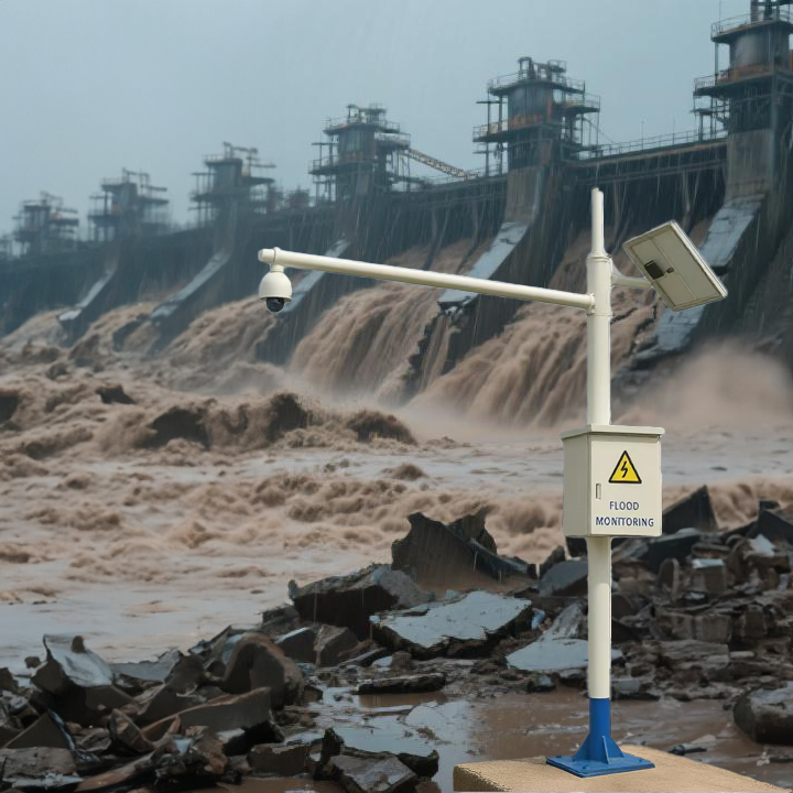
2. Hydrological Radar Flowmeter: The “Core Analyst”
* Role: This is a non-contact, advanced流速 (flow velocity) and流量 (discharge) monitoring device. Typically mounted on bridges or banks above the water, it emits radar waves towards the water surface. Using the Doppler effect principle, it accurately measures the surface velocity of the river and, combined with water level data (often from an integrated water level gauge), calculates the instantaneous discharge (in cubic meters per second) at the cross-section in real-time.
* Position in the System: It is the core of the flood early warning system. Discharge is the most critical indicator of flood magnitude, directly determining the scale and potential damage of a flood peak. Compared to traditional contact-based流速 meters, radar flowmeters are unaffected by flood scour or debris impact. They remain operational during extreme flood events, providing invaluable “in-the-moment” data and enabling direct, real-time, and precise monitoring of river conditions.
3. Displacement Sensor: The “Facility Guardian” and “Secondary Disaster Whistleblower”
* Role: This category includes various sensors (e.g., GNSS, inclinometers, crack meters) used to monitor minute deformations, settlement, or displacement of water infrastructure such as reservoir dams, levees, and slopes. They are installed on critical structural points to continuously measure positional changes.
* Position in the System: It is the guardian of engineering safety and secondary disaster warning. The danger of floods comes not only from the water volume itself but also from structural failures. Displacement sensors can provide early detection of potential dam leakage or deformation, landslide risks on embankments, or slope instability. If monitored data exceeds safety thresholds, the system triggers an alarm for major risks like piping, dam failure, or landslides, thereby preventing catastrophic floods caused by structural failure.
II. Collaborative Workflow
These three components work in synergy, forming a complete warning loop:
- The Rain Gauge is the first to report “how much rain is falling from the sky.”
- Hydrological models predict the potential runoff and flood peak discharge based on this rainfall data.
- The Hydrological Radar Flowmeter at key river sections verifies these predictions in real-time, reporting “how much water is actually in the river,” and provides more accurate warnings about the flood peak’s arrival time and magnitude based on the rising discharge trend.
- Simultaneously, the Displacement Sensor rigorously monitors whether the “container holding the water” is safe, ensuring floodwater is released in a controlled manner and preventing greater disasters caused by structural failure.
III. Profound Impacts
1. Greatly Enhanced Warning Accuracy and Timeliness:
* Real-time discharge data from hydrological radar significantly reduces the uncertainty of traditional rainfall-based flood forecasts. This shifts warnings from “prediction” to “real-time reporting,” buying precious hours or even tens of hours of golden time for downstream evacuations and emergency response.
2. Improved Capability to Respond to Extreme Flood Events:
* Non-contact measurement allows radar flowmeters to function normally during historic major floods, filling critical data gaps during the most severe phase of the disaster. This provides visible evidence for command decisions, preventing “fighting in the dark” at the most critical moments.
3. Expansion from Flood Warning to Structural Safety Warning for Comprehensive Disaster Prevention:
* The integration of displacement sensors upgrades the warning system from purely hydrological forecasting to an integrated “hydrological-structural” safety warning system. It can warn against not only “natural disasters” but also effectively prevent “man-made disasters” (structural failures), greatly enhancing the depth and scope of the disaster prevention system.
4. Promotion of Smart Water Management and Digitalization:
* The vast amounts of real-time data generated by these sensors form the foundation for building a “Digital Twin Watershed.” Analysis through big data and artificial intelligence allows for continuous optimization of hydrological models, enabling smarter flood simulation, forecasting, and reservoir operation, ultimately leading to refined and intelligent water resource management.
5. Generation of Significant Economic and Social Benefits:
* Accurate warnings minimize casualties and property damage. The losses avoided by taking measures such as closing gates in advance, moving assets, and evacuating populations far exceed the investment in building these monitoring systems, resulting in a high return on investment. Furthermore, it enhances public safety and confidence in the disaster prevention system.
Complete set of servers and software wireless module, supports RS485 GPRS /4g/WIFI/LORA/LORAWAN
For more sensors information,
please contact Honde Technology Co., LTD.
Email: info@hondetech.com
Company website: www.hondetechco.com
Tel: +86-15210548582
Post time: Sep-18-2025