
As typhoons and droughts batter the archipelago, the nation’s “rice granary” is quietly deploying technology from the aerospace and industrial sectors, transforming the unpredictable pulse of its rivers into actionable data for farmers.
In 2023, Super Typhoon Goring carved across Luzon, causing over ₱3 billion in agricultural losses. But in Nueva Ecija—the heart of the Philippines’ “rice granary”—some leaders of irrigation cooperatives did not lose sleep as they might have in years past. On their phones, an application quietly displayed real-time water level and flow data from key sections of the upstream Magat and Pampanga rivers. This data came from a device known as a “non-contact sentinel”: the hydrological radar level sensor.
For Philippine agriculture, which is highly dependent on natural irrigation, water is both the source of life and the most uncontrollable risk. Traditionally, water masters relied on experience, rain gauges, and occasional, hazardous manual measurements to guess the river’s mood. Today, a technological infiltration aimed at using certainty to combat uncertainty is beginning at critical rivers and irrigation canals.
The Core Challenge: Why the Philippines? Why Radar?
The water management dilemmas facing Philippine agriculture are precisely the scenarios where radar technology excels:
- The “Double Threat” of Extreme Weather: Typhoons bring floods during the rainy season, while water scarcity strikes during the dry season. Agriculture requires precise timing for water storage and release.
- The Fragility of Infrastructure: Many irrigation systems are old and canals are heavily silted. The lack of water level data leads to uneven water distribution and frequent disputes between upstream and downstream users.
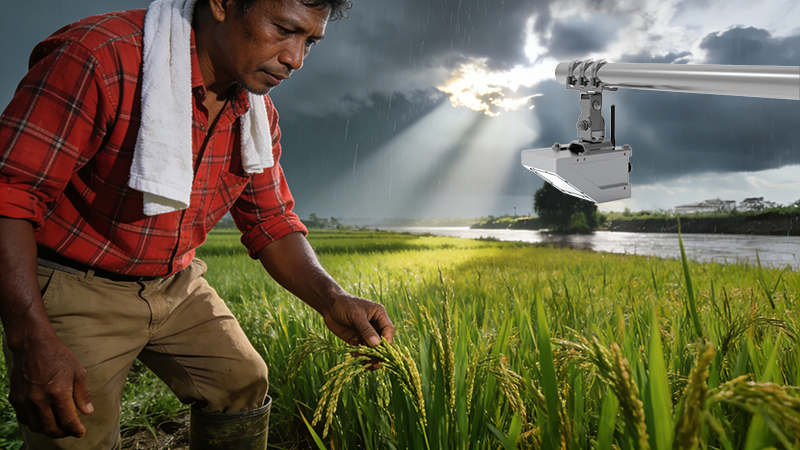
- Matching “Value” with “Profile”: Compared to expensive, complex-to-install contact sensors, modern radar level sensors have seen a significant price drop. They can achieve “install-and-forget” unmanned monitoring in remote areas using solar power and wireless networks (like cellular). Their non-contact measurement capability makes them impervious to debris, silt, and turbulence during floods.
Application Scenarios: The Data Loop from Warning to Optimization
Scenario 1: The Typhoon Season’s “Flood Guard”
In the Cagayan Valley, the water authority deployed a radar network on major upstream tributaries. When the radar detects a sharp 50cm rise in water level within 3 hours due to continuous heavy rain in the mountains, the system automatically sends alerts to all mid- and downstream irrigation districts and low-lying villages. This provides the crucial 6-12 hour golden window for harvesting fields, clearing drainage, and moving assets, turning “passive victimhood” into “active disaster prevention.”
Scenario 2: The Dry Season’s “Water Allocation Actuary”
In irrigation districts around Laguna de Bay, radar monitors the real-time water level at intake points. Combined with rainfall forecasts and soil moisture data, a simple AI model can predict area-wide water consumption for the next 5 days. Irrigation associations then create rotation schedules precise to the hour, disseminated to farmers via SMS. This reduced waste and conflict from disorderly water scrambling, improving irrigation efficiency by about 20% during the 2023 dry season.
Scenario 3: The “Joint Dispatcher” for Reservoirs and Rivers
In the Pampanga River basin, radar data is integrated into a larger “Smart Basin” management system. The system analyzes river levels and upstream reservoir storage in real-time. Before a typhoon, it recommends pre-releasing water to increase flood storage capacity; before a dry season, it advises pre-storing water. The real-time data provided by radar makes this delicate balancing act possible.
Scenario 4: Supporting the National “Climate-Smart Agriculture” Strategy
The Philippine Department of Agriculture is promoting climate-adaptive farming practices. The long-term, continuous hydrological dataset provided by radar becomes the key evidence for validating and optimizing these practices (like adjusting rice planting calendars or promoting drought-resistant varieties). Data proves the effectiveness of interventions, helping secure more international climate adaptation funding.
Localization Challenges and Community Integration
Successful application in the Philippines requires deep adaptation to local conditions:
- Power & Communications: Utilizing low-power design + solar panels + 4G/LoRaWAN hybrid networks ensures operation continues for days even in remote mountains or during typhoon-induced blackouts.
- Disaster-Resistant Design: Sensor mounting poles are reinforced to withstand strong winds and flood impacts. Antennas have lightning and bird-nest protection.
- Community Empowerment: Data doesn’t stay in government offices. Through simple color-coded (red/yellow/green) SMS alerts and community radio, even grassroots farmers can understand and use this information, translating technology into community action.
Future Outlook: From Points to a Networked Water Map
A single radar station is just a point. The Philippine vision is to build a national “Hydrological Sensing Network,” fusing river radar stations, rain gauges, soil sensors, and satellite remote sensing data. This will generate a “Real-Time Water Balance Map” for the country’s major agricultural regions, fundamentally enhancing national water resource planning and agricultural disaster resilience.
Conclusion: When Traditional Agriculture Meets Aerospace-Grade Sensing
For generations of Filipino farmers who have “farmed by the weather,” the unassuming silver device on a tower by the river upstream represents a profound shift: from praying to deities for favorable weather to rationally negotiating climate volatility with data.
Complete set of servers and software wireless module, supports RS485 GPRS /4g/WIFI/LORA/LORAWAN
For more radar level sensor information,
please contact Honde Technology Co., LTD.
Email: info@hondetech.com
Company website: www.hondetechco.com
Tel: +86-15210548582
Post time: Dec-11-2025