
In an era of intensified climate change, traditional water level gauges only measure “height” like measuring a person’s stature, while Doppler hydrological radar listens to water’s “heartbeat”—providing unprecedented three-dimensional insights for flood control and water resource management.
During floods, what we need to know most is not only “how high is the water” but also “how fast is it flowing.” Traditional water level sensors are like silent rulers, only recording vertical numerical changes, while Doppler hydrological radar acts like a detective fluent in water language, simultaneously interpreting both water depth and flow velocity, upgrading one-dimensional data to four-dimensional spatiotemporal insights.
Physics Magic: When Radar Waves Meet Flowing Water
The core principle of this technology originates from the physical phenomenon discovered in 1842 by Austrian scientist Christian Doppler—the Doppler Effect. The familiar experience of an ambulance siren rising in pitch as it approaches and falling as it recedes is the acoustic version of this effect.
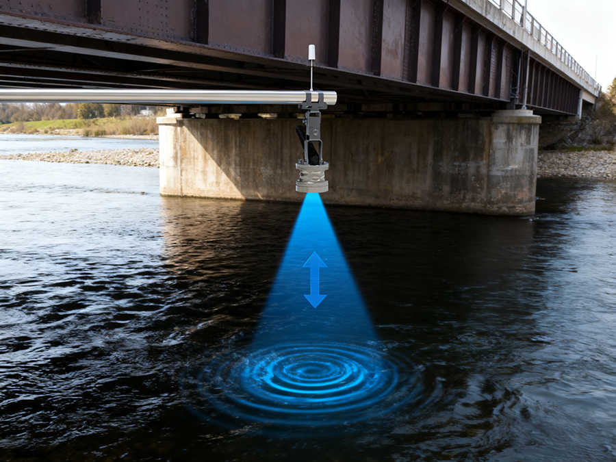
When radar waves strike flowing water surfaces, a precise physical dialogue occurs:
- Velocity Detection: Suspended particles and turbulent structures in the water flow reflect radar waves, causing frequency shifts. By measuring this “frequency change,” the system accurately calculates the surface flow velocity
- Water Level Measurement: Simultaneously, the radar measures beam travel time to accurately obtain water level height
- Flow Calculation: Combined with cross-sectional geometric models (obtained through pre-surveys or laser scanning of river/channel shapes), the system calculates cross-sectional flow rate (cubic meters/second) in real time
Technological Breakthrough: From Point Measurement to Systemic Understanding
1. Truly Non-Contact Monitoring
- Installed 2-10 meters above water surface, completely avoiding flood damage
- No submerged components, unaffected by sediment, ice, or aquatic organisms
- Stable operation even during flood peaks with abundant floating debris
2. Unprecedented Data Dimensions
- Traditional methods require separate installation of water level gauges and flow meters, with manual data integration
- Doppler radar provides integrated real-time data streams:
- Water level accuracy: ±3 mm
- Flow velocity accuracy: ±0.01 m/s
- Flow rate accuracy: better than ±5% (after field calibration)
3. Intelligent Flood Warning Systems
In the Netherlands’ “Room for the River” project, Doppler radar networks achieved precise flood peak predictions 3-6 hours in advance. The system predicts not only “how high the water will rise” but also “when the flood will reach downstream cities,” winning critical time for evacuation and调度.
Application Scenarios: From Mountain Streams to Urban Canals
Hydroelectric Power Plant Optimization
Hydroelectric plants in the Swiss Alps use Doppler radar for real-time inflow monitoring, dynamically adjusting power generation plans. 2022 data shows that through precise snowmelt runoff prediction, one power plant increased annual generation by 4.2%, equivalent to reducing 2000 tons of CO₂ emissions.
Urban Drainage System Management
Tokyo Metropolitan Area deployed 87 Doppler monitoring points, forming the world’s densest urban hydrological radar network. The system identifies drainage bottlenecks in real time and automatically adjusts sluice gates during rainstorms, successfully preventing 3 major flooding incidents in 2023.
Precision Agricultural Irrigation Scheduling
Irrigation districts in California’s Central Valley link Doppler radar with soil moisture sensors to achieve “flow-based allocation” smart irrigation. The system dynamically adjusts sluice gate openings based on real-time flow rates, saving 37 million cubic meters of water in 2023.
Ecological Flow Monitoring
In the Colorado River ecological restoration project, Doppler radar continuously monitors minimum ecological flows for fish migration. When flow falls below thresholds, the system automatically adjusts upstream reservoir releases, successfully protecting the 2022 spawning season of endangered humpback chub.
Technological Evolution: From Single Points to Network Intelligence
New-generation Doppler hydrological radar systems are developing in three directions:
- Networked Cognition: Multiple radar nodes form watershed-scale “hydrological neural networks” via 5G/Mesh networking, tracking flood wave propagation through basins
- AI-Enhanced Analysis: Machine learning algorithms identify flow structures (like vortices, secondary flows) from Doppler spectra, providing more accurate velocity distribution models
- Multi-Sensor Fusion: Integration with weather radar, rain gauges, and satellite data builds “air-space-ground integrated” smart hydrological monitoring systems
Challenges and Future: When Technology Meets Natural Complexity
Despite technological advancement, Doppler hydrological radar still faces environmental challenges:
- Extremely turbid water with high suspended sediment concentrations may affect signal quality
- Aquatic vegetation-covered surfaces require special signal processing algorithms
- Ice-water mixed flows need dedicated two-phase flow measurement modes
Global R&D teams are developing:
- Multi-band radar systems (Ku-band combined with C-band) adapting to different water quality conditions
- Polarimetric Doppler technology distinguishing surface waves from underwater flow velocities
- Edge computing modules completing complex signal processing at the device end, reducing data transmission needs
Conclusion: From Monitoring to Understanding, From Data to Wisdom
Doppler hydrological radar represents not just measurement tool advancement but a paradigm shift in thinking—from viewing water as “an object to be measured” to understanding it as “a living system with complex behaviors.” It makes invisible flows visible and vague hydrological predictions precise.
In today’s climate of frequent extreme hydrological events, this technology is becoming a crucial medium for harmonious human-water coexistence. Each captured frequency shift, each generated velocity-water level dataset represents an attempt at human intelligence interpreting natural language.
Next time you see a river, remember: somewhere above the water surface, invisible radar waves are conducting millions of “conversations” per second with the flowing water. The results of these conversations are helping us build a safer, more sustainable water future.
Complete set of servers and software wireless module, supports RS485 GPRS /4g/WIFI/LORA/LORAWAN
For more water radar sensor information,
please contact Honde Technology Co., LTD.
Email: info@hondetech.com
Company website: www.hondetechco.com
Tel: +86-15210548582
Post time: Dec-02-2025