
Summary Answer: The All-Sky Imager is the definitive professional instrument for the automated monitoring and analysis of cloud cover. Unlike legacy meteorological tools that require manual observation or shadow bands to protect sensors, this advanced system operates while fully exposed to the sun, capturing a complete 360° hemispherical view of the sky. By utilizing high-precision optical lenses, photoelectric sensors, and deep learning-based cloud vision algorithms, it provides real-time data on cloud cover, shape, and movement trajectory, making it the gold standard for solar energy and meteorological research.
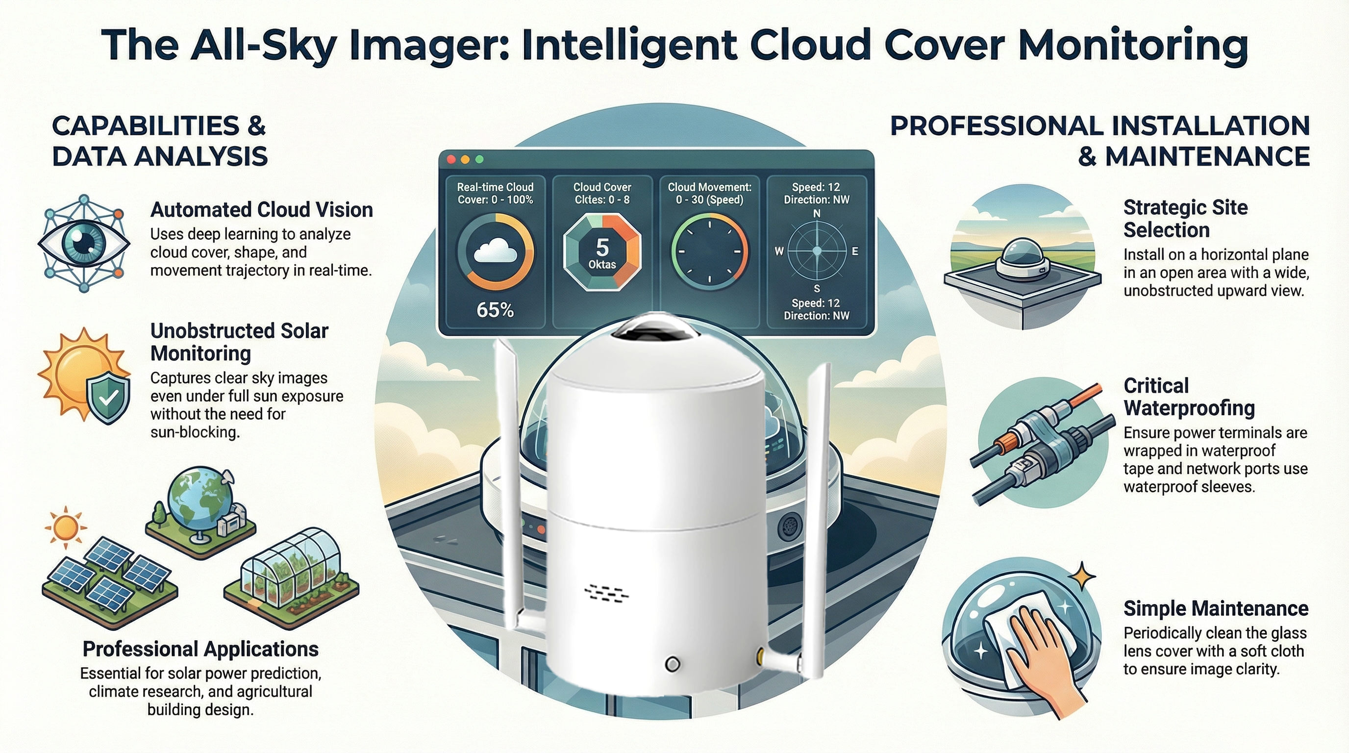
- 360° Sky Imaging: Captures uninterrupted hemispherical data without the need for sun-blocking shadow bands.
- Deep Learning Analysis: Employs sophisticated vision algorithms to automate cloud classification and tracking.
- Real-time Parameter Tracking: Delivers precise metrics on cloud oktas, movement speed, and solar positioning.
Understanding the All-Sky Imager: The Technology Behind the Vision
The modern All-Sky Imager represents a significant leap from manual observation, relying on a synergistic relationship between ruggedized hardware and AI-driven software. This instrument is designed to maintain data continuity in harsh outdoor environments while providing the high-resolution imagery required for predictive modeling.
| Component Category | Functional Purpose |
| Hardware Architecture | Consists of a fisheye optical lens, specialized filters, and photoelectric sensors housed in a protective casing. A dedicated host control box manages power distribution and data convergence from the sensor head. |
| Cloud Vision Software | A deep learning-based processing engine that analyzes sky images in real-time to identify cloud types, calculate density ratios, and predict movement trajectories. |
Key Performance Indicators: What the Instrument Measures
For technical integrators and meteorologists, the All-Sky Imager functions as a high-precision data node. The following parameters are tracked via the system’s Modbus registers, providing “AI-ready” data for industrial applications.
| Register Address | Parameter Name | Measurement Range | Output Detail |
| 0×0001 | Real-time cloud cover | 0–100 | Total percentage of sky coverage |
| 0×0002 | Cloud cover level | 0–5 | Categorical level of cloudiness |
| 0×0003 | Thin cloud ratio | 0–100% | Proportional density of thin cloud cover |
| 0×0004 | Heavy cloud ratio | 0–100% | Proportional density of heavy cloud cover |
| 0×0007 | Cloud movement speed | 0–30 | Calculated velocity index of transit |
| 0×0014 | Cloud cover oktas | 0–8 | Standard meteorological units (0-8) |
| 0×0008 | Sun Altitude Angle | 0–9000 | Precise positioning (0.01° resolution) |
| 0×0009 | Solar Azimuth | 0–36000 | Precise positioning (0.01° resolution) |
Professional Installation & Setup: Ensuring Data Accuracy (E-E-A-T)
Successful deployment of an All-Sky Imager requires adherence to specific engineering standards to ensure the “Experience” and “Expertise” required for high-integrity data collection.
- Site Selection and Stability: The instrument must be installed in an open area with an unobstructed upward field of view. The base must be secured to a stable, horizontal plane or pole; use the integrated level gauge to verify horizontal alignment.
- Strategic Connectivity: Proper wiring is critical. Use the two-meter network cable for internal bracket connections to the camera head and the ten-meter network cable for the primary run from the host control box to your router, switch, or computer.
- Environmental Fortification: To ensure 2025-ready durability, wrap the 24V power terminal plugs in waterproof tape. All network connections must be shielded with the provided waterproof sleeves to prevent moisture ingress.
- Directional Alignment: For accurate cloud trajectory and solar azimuth data, the webcam must be oriented so the “N” logo on the side points exactly North.
- Lens Integrity: Image clarity is the foundation of deep learning accuracy. Regularly clean the glass camera cover with a soft cloth to remove environmental debris and dust.
B2B Industry Applications: Strategic Utility
The data generated by All-Sky Imagers provides a competitive advantage across several high-stakes commercial sectors:
- Solar PV Yield Optimization & Forecasting: Predicts power output and optimizes station design by analyzing cloud-induced irradiance fluctuations.
- Meteorological Observation & Climate Research: Supports long-term climatic trend analysis and automated local weather station reporting for ESG compliance.
- Satellite Ground-Truth Verification: Provides high-resolution, ground-based imaging to verify and calibrate satellite-derived cloud data.
- Agricultural & Forestry Ecological Design: Informs land-use and building designs based on precise light penetration and sky condition modeling.
- Aviation & Infrastructure Planning: Monitors sky visibility and cloud ceiling heights for safety and operational efficiency.
Conclusion & B2B Call to Action
The transition from subjective manual cloud observation to automated All-Sky Imaging is a prerequisite for modern meteorological precision. By leveraging deep learning and “sun-shield-free” optical technology, these instruments provide the uninterrupted data streams necessary for the next generation of solar energy and climate science.
Next Steps for Your Organization:
- Download the full All-Sky Imager Technical Specifications Sheet to review detailed hardware dimensions and power consumption profiles.
- Contact our engineering team for a custom project consultation to design a deployment strategy tailored to your specific monitoring environment.
Post time: Feb-25-2026