

Nusantara is being built in a rainforest. That single fact determines more engineering decisions than any architectural rendering. The site, in East Kalimantan on the island of Borneo, receives 2,200 to 3,000 millimeters of rain per year, concentrated in the November-to-May wet season. The terrain is hilly, with steep drainage gradients, and the soil is deep tropical clay that saturates quickly and sheds water laterally. The Indonesian government’s own flood-susceptibility assessments, published in planning studies, classify significant portions of the capital’s construction zone as high-risk for flash flooding during extreme rainfall events.
The city is not being built on a blank slate. It is being built on a hydrological network that already exists — a set of rivers and streams that currently drain undisturbed forest and small settlements. When 500,000 residents eventually occupy the city, those same waterways will carry urban runoff from roads, roofs, and parking surfaces. The flood response must be designed in from the start, not retrofitted after the first disaster.
This is why the Nusantara Capital Authority’s procurement lists include dense rainfall monitoring as a foundational layer. The city’s “100% digital and ICT connectivity” mandate — published in the IKN master plan — is not a broadband slogan. It means every environmental sensor, including rainfall, is specified as a networked, data-transmitting instrument from day one.
What a Rainforest Capital Needs That Other Cities Don’t
A city built in a rainforest faces a rainfall-monitoring problem that temperate cities do not: spatial variability at extreme intensity. In East Kalimantan, convective storms are cellular and violent. A storm cell 3 kilometers wide can deposit 80 millimeters of rain on one drainage basin while the adjacent basin, 4 kilometers away, receives nothing. The difference of a few hundred meters determines which creek channel overflows and which residential block floods.
The BMKG (Indonesia’s meteorological agency) maintains synoptic stations at regional scale. Their spacing — typically 30 to 60 kilometers — is useless for basin-scale flood warning in terrain this variable. The rain that floods a specific catchment must be measured in that catchment, not inferred from a station two districts away.
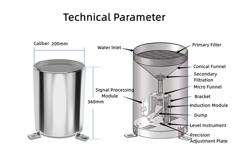
The Honde smart-city rain gauge specified for the Nusantara deployment addresses this with three engineering decisions.
RS485 Modbus-RTU output
The sensor transmits rainfall as a digital data packet — instantaneous intensity, daily accumulation, monthly total — over a standard industrial protocol. This is not a pulse output that requires a counting datalogger to interpret. The RS485 signal connects directly to the city’s environmental IoT gateway, the same backbone that carries water level, water quality, and air quality data. One network, one protocol, no protocol converters.
0.2mm resolution
The tipping bucket mechanism registers every 0.2mm of rainfall. At tropical rain intensities — East Kalimantan storms routinely produce 60-100mm per hour — a coarser 0.5mm gauge misses the fine structure of the intensity curve that distinguishes “heavy but manageable” from “flood-producing.” The 0.2mm resolution captures the rate-of-rise data that triggers pre-emptive drainage pump activation.
304 stainless steel construction
The gauge body is built for 20 years of continuous outdoor exposure in a tropical climate — UV radiation at 3,500 hours of annual sunshine, 95% humidity, and nesting insects. The anti-insect mesh at the funnel inlet prevents the blockages that kill plastic gauges in their first wet season.
The Solution Architecture for a New Capital
The Nusantara deployment is being designed as a single integrated network, not a collection of standalone stations.
Tier 1 — Local instrumentation
Rain gauges are mounted on standard communication masts at each drainage-basin monitoring point, co-located with water level radar sensors on the streams they feed. A Data logger with screen at each node displays current rainfall intensity and 24-hour accumulation to on-site contractors and engineers — critical during the construction phase, when the city’s buildings and roads are being poured and flash floods directly threaten worker safety and fresh concrete.
Tier 2 — Transmission
Each node transmits via GPRS, 4G, WIFI, LoRa, or LoRaWAN wireless modules, selected based on construction-phase connectivity at each location. As the city’s fiber backbone comes online, nodes will migrate to wired connections while retaining the wireless path as redundancy. All data is packetized in MQTT Json format, feeding directly into the Nusantara Capital Authority’s centralized smart-city platform — the same data layer that will eventually integrate traffic, power, and water distribution.
Tier 3 — Cloud and warning
The Cloud server and software consolidates rainfall, water level, and weather data into a single dashboard, showing real-time data and history data across all monitored basins. The Alarm relay system is configured for two thresholds. At 30mm in 30 minutes, the relay alerts the construction-management office — sufficient warning to suspend work in low-lying excavation areas and move equipment to high ground. At 50mm in 30 minutes, the relay escalates to the emergency operations center and automatically activates the pre-positioned pumps in the affected drainage basin.
Field technicians use the Handmeter during quarterly verification rounds to confirm gauge accuracy against a controlled-reference portable rain source, before each wet season.
The Jakarta Parallel: Why the Same Sensor is Retrofitting a Sinking City
Nusantara is the future. Jakarta is the present crisis. The city is sinking at rates up to 25 centimeters per year in northern districts — the result of decades of groundwater extraction from unconfined aquifers — while simultaneously flooding harder each monsoon. In 2025, Jakarta recorded its highest annual rainfall in 25 years, and the northern flood-control pumps at the Pluit and Waduk Sunter reservoirs operated near capacity for 3 consecutive months.
Jakarta’s flood management problem is not the absence of data. It is the density of data. The BPBD (regional disaster management agency) relies on a mix of BMKG stations and a sparse network of local gauges. The gaps between gauges are exactly where the worst local flooding occurs — in the narrow alleyways and informal settlements of the northern districts that sit below sea level during high tide.
The same Honde smart-city gauge deployed in Nusantara is being retrofitted into Jakarta’s existing flood network at 200 locations, prioritized by historical flood records. The RS485 output connects to the city’s existing telemetry gateways — most Jakarta pumping stations already run industrial PLCs that accept Modbus — enabling integration without replacing the control infrastructure.
Field Results: Nusantara Phase-1 Drainage Basins, March–July 2026
The first deployment of 60 Honde smart-city rain gauges was commissioned in March 2026 — the tail end of the wet season — across 12 primary drainage basins within the Nusantara Government Zone construction area.
Operational results after 4 months (through the wet-season transition):
- The network logged 27 rainfall events exceeding 30mm in 30 minutes between March and July, including one event that deposited 104mm in 60 minutes on the Sepaku River basin — the highest recorded intensity at the site since construction began.
- The Alarm relay system triggered 9 construction-suspension alerts during the period. In two cases, contractor teams working in low-lying excavation areas received the alert with sufficient lead time to move equipment — the first time such losses were prevented by rainfall data in the project’s history.
- During the July storm season transition, the network’s rate-of-rise data enabled the Sepaku River flood-control gates to be pre-positioned 45 minutes before peak discharge — a decision previously made reactively after water level observations.
- The handmeter verification program conducted ahead of the November wet season found zero calibration drift exceeding ±5% across all 60 gauges — the 304 stainless steel mechanism had survived the March-to-July construction dust, heavy rain, and tropical heat without measurable degradation.
- Data from the network is now feeding the hydrological models used to finalize the city’s drainage design standards — the first time the capital’s engineering specifications have been calibrated against actual site rainfall rather than regional assumptions.
Contact Honde Technology for Smart City Monitoring Tenders
Honde Technology is a Germany TUV & Alibaba verified manufacturer. We supply the rainfall monitoring hardware, the RS485 digital backbone, and the multi-protocol wireless integration logic required for smart cities being built from the ground up.
For more sensor information and customized IoT solutions, please contact Honde Technology Co., LTD.
- WhatsApp: +86-15210548582
- Email: info@hondetech.com
- Company Website: www.hondetechco.com
Post time: Aug-06-2026