

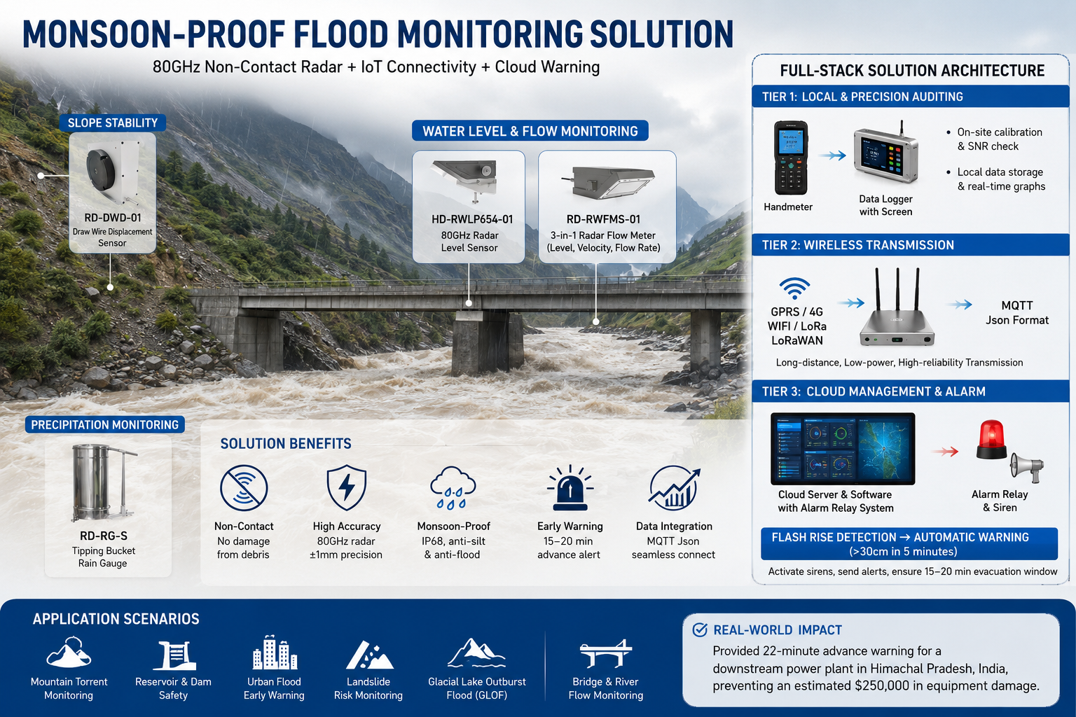
The June Crisis: The Failure of “Submerged” Infrastructure
As of June 2026, the arrival of the monsoon across the Indian Himalayas and Vietnam’s Ha Giang province has exposed a critical vulnerability in traditional hydrology. During “Flash” events, where water stages rise 2 meters in under 10 minutes, traditional pressure transducers and submerged Doppler meters frequently fail due to:
- 1 Debris Impact: Floating tree trunks and boulders smash contact-based sensors within the first hour of a surge.
- 2 Silt Burial: High-sediment floodwaters bury sensors under 30cm of mud, rendering them useless for the remainder of the season.
The engineering consensus has shifted: If a sensor touches the water during a flash flood, it is a liability. To ensure data survival, Honde Technology’s Mountain Torrent Series operates entirely in the “Air Gap” above the flood stage.
The Perception Layer: 80GHz Precision and Slope Stability
Honde’s EWS architecture utilizes high-frequency millimeter-wave technology to achieve surgical precision in rugged terrain:
01 1. 80GHz Narrow-Beam Level Radar (HD-RWLP654-01)
In narrow mountain gorges, standard radar sensors suffer from wall reflections. Our 80GHz radar features a focused 6° beam angle.
- The Advantage: It ignores bridge pillars and overhanging vegetation, providing ±1mm accuracy even during turbulent surges. It “sees” the water surface clearly where wider beams see only noise.
02 2. 3-in-1 Radar Flow Meter (RD-RWFMS-01)
Installed on bridge decks, this unit integrates Level, Surface Velocity, and Flow Rate (
m3/s) calculation. It tracks the “Discharge Flux” of the river without ever touching the silty water.
03 3. Slope Displacement Tracking (RD-DWD-01)
Flash floods are often preceded by landslides. Our wire-draw displacement sensors are anchored to vulnerable slopes above the river. They detect sub-millimeter soil movements, providing the primary signal for potential river blockages (temporary dams) that cause catastrophic downstream bursts.
The Honde Full-Stack Solutions Architecture
Deploying a regional flood grid requires a resilient, three-tier data loop designed for “No-Failure” operations:
Tier 1: Local Awareness & Precision Auditing
- Field Audit Tools: Maintenance crews utilize the Honde Handmeter for rapid on-site calibration and SNR (Signal-to-Noise Ratio) checks during installation.
- On-Site Persistence: Every station is anchored by our Data Logger with screen, providing local emergency managers with real-time level/velocity graphs and 30-day graphical history on-site—critical for making tactical evacuation decisions when the main network is congested.
Tier 2: The Wireless Nervous System (Transmission)
- Connectivity Excellence: Terminals support GPRS/4G/WIFI/LORA/LORAWAN wireless modules.
- The MQTT Logic: For national emergency integrators, data is transmitted in MQTT Json format. This standardized format allows high-resolution hydrology data to feed directly into provincial flood dashboards and “Digital Twin” modeling software without proprietary middleware.
Tier 3: Cloud Management & Active Warning (The Safety Loop)
- All data is centralized on the Cloud server and software with alram relay system support to see the real time data, history data, providing 24/7 visibility into the watershed’s status.
- The Life-Saving Loop: This is the core ROI. When the 80GHz radar detects a “Flash Rise” (e.g., >30cm in 5 minutes), the cloud platform triggers a physical Alarm Relay system on-site. This automatically activates Acoustic-Optical sirens in downstream villages—triggering a 15-minute evacuation window before the flood crest arrives.
Real-World Case Study: GLOF Monitoring in Himachal Pradesh, India
A B2B civil engineering group in India required a high-reliability network for the Beas River basin to monitor Glacial Lake Outburst Floods (GLOF).
The Honde Intervention:
- Hardware: Deployed 15 units of 80GHz Level Radars and 0.2mm Stainless Steel Rain Gauges.
- Connectivity: Used LoRaWAN gateways transmitting in MQTT Json format over 12km of rugged mountainous terrain.
- The Outcome: During the June 2026 monsoon, the system successfully survived three massive surges. The Alarm Relay System provided a 22-minute advance warning for a downstream power plant, allowing them to secure their intake gates and preventing an estimated $250,000 in equipment damage.
Contact Honde Technology for Hydrology Tenders
For more sensor information and customized IoT solutions, please contact Honde Technology Co., LTD.
Post time: Jul-13-2026