

The November 2021 atmospheric river event in British Columbia produced rainfall totals of 100 to 300 mm in 48 hours across the Cascade and Coast Mountain ranges. The Coquihalla River, a fast-gradient stream carved through Fraser Canyon, rose 6 meters in under 24 hours. Highway 5 — the primary interior supply route — was severed at multiple points. Merritt was evacuated. Abbotsford flooded under 2 meters of agricultural runoff. The final damage assessment exceeded CA$1 billion, making it the costliest natural disaster in BC’s recorded history.
The BC River Forecast Centre (BCRFC) operates more than 200 hydrometric monitoring stations across the province. During the November event, 14 stations in the affected watersheds went offline — not because the electronics failed, but because the physical sensors were destroyed. Conventional pressure transducers and float-operated sensors in the Fraser and Nooksack systems were hit by debris loads — fallen trees, boulders, bridge wreckage — that simply removed them from their mounting points. The BCRFC had accurate data up to the moment the sensors disappeared.
The lesson was not subtle. A flood monitoring station that fails at the moment of maximum flood is not a monitoring station — it is a weather vane. The procurement specification that has emerged from the 2021 event review is consistent: contact-based sensors are off the preferred equipment list for BC’s high-gradient, debris-loaded rivers. The 24GHz FMCW non-contact radar is on it.
The Physics of a BC Atmospheric River Flood
British Columbia’s atmospheric river events differ from the convective flash floods of the Mediterranean or the monsoon surges of South Asia in two important ways. First, they last longer — 12 to 72 hours of sustained extreme rainfall across large catchments, rather than a 2-to-4-hour convective cell. Second, the rivers they load are steep, fast, and cold, running through recently glaciated terrain with abundant loose rock and timber.
When a BC mountain river runs at full flood, the suspended load includes everything the current can move: gravel, boulders to 1 meter diameter, root balls from upslope landslides, and log volumes from riparian erosion. This is not the silty suspension of a lowland agricultural river. It is a slurry that moves at 4 to 8 meters per second. Any instrument that sits in this current — a pressure transducer, an acoustic Doppler unit, a bubbler tube — is subject to direct physical impact.
The 24GHz FMCW radar mounts on the bridge deck or a cantilever arm, 3 to 12 meters above the channel bed. It measures the water surface by detecting the frequency shift between the transmitted and reflected microwave signal. The current, the debris, the boulders, the log jams — none of these make contact with the instrument. The radar reads a rushing debris-laden torrent with the same accuracy it reads a calm mountain lake.
The Sensor
| Specification | Value |
|---|---|
| Measurement technology | 24GHz FMCW (Frequency Modulated Continuous Wave) |
| Measurement range | 0.1 to 30 m (non-contact, above water) |
| Level accuracy | ±3 mm |
| Operating temperature | −40°C to +70°C |
| Surge protection | 6,000 V integrated |
| Housing | IP68, weatherproof |
| Output | RS485 Modbus-RTU |
| Wireless | GPRS / 4G / WiFi / LoRa / LoRaWAN |
| Data format | MQTT Json |
| Power | 9–30 VDC, solar-battery compatible |
The −40°C operating floor is not a standard specification for a southern-latitude sensor — it is the minimum required for BC Interior deployments, where the Thompson River basin records January lows below −35°C. The 6,000V surge protection addresses BC’s high lightning frequency in summer convective events that often precede the most damaging September and October floods.
The Station Architecture
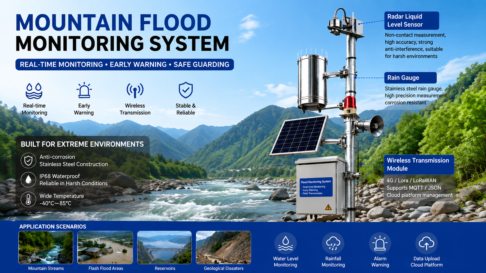
The standard BCRFC-compatible station architecture integrates the radar level sensor with a stainless steel 0.2mm tipping bucket rain gauge — rain intensity in the upstream catchment is the 30-to-60-minute predictor of the river rise the radar will subsequently measure. Together, the two instruments close the monitoring chain:
| Instrument | Parameter | Role in warning chain |
|---|---|---|
| 0.2 mm stainless tipping bucket | Rainfall intensity (mm/h) | Triggering threshold — 30 min lead time |
| 24GHz FMCW radar level | River stage (m) | Confirmation — stage rise confirmation |
| Temperature sensor (integrated) | Air temperature | Ice/snowmelt context |
| Data logger with screen | All parameters | Local display + 90-day storage |
The Solution Architecture
Tier 1 — Station instrumentation. The radar sensor mounts on a galvanized gantry or bridge parapet, pointed vertically down at the river. The rain gauge mounts 1 to 2 meters above the sensor enclosure on the same mast. A Data logger with screen in the weatherproof station enclosure stores 90 days of 15-minute interval data for both instruments, displaying current stage, current rainfall intensity, and transmission status. The BCRFC hydrometric technician uses the Handmeter during quarterly site visits — a portable reference current meter for velocity and a GPS survey for the stage datum — confirming the radar reading against independent field measurement before the comparison enters the BCRFC quality-assurance record.
Tier 2 — Transmission. Valley-bottom stations near populated communities use 4G direct to the BCRFC operational platform. Ridge and mountain pass stations, where cellular coverage thins or disappears, use LoRaWAN to relay data to gateways at the nearest highway maintenance yard or Environment Canada weather station. All data is packetized in MQTT Json format, feeding both the BCRFC provincial flood forecasting model and the Public Safety Canada National Disaster Mitigation Program alert system.
Tier 3 — Cloud and warning cascade. The Cloud server and software consolidates stage and rainfall from all stations, showing real-time data and history data across the province’s monitored watersheds. The Alarm relay system implements a three-level cascade based on BCRFC’s established thresholds:
| Alert level | Trigger condition | Relay action |
|---|---|---|
| Flood Watch | Stage rising > 0.5 m/h + rainfall > 20 mm/h | BCRFC duty forecaster notification |
| Flood Warning | Stage > flood-action level (site-specific datum) | Automated Emergency Alert System notification to affected municipalities |
| Flood Emergency | Stage rising > 1.0 m/30 min | Direct escalation to BC Emergency Management; downstream bridge closures |
Field Results: Fraser and Thompson Basin Deployments, 2026
BC’s Ministry of Environment and Climate Change commissioned 60 radar-plus-rain-gauge stations across the Fraser and Thompson basins between October 2025 and March 2026 — covering the catchments where the 2021 event destroyed the most monitoring infrastructure.
Hardware: 60 24GHz FMCW radar level sensors + 60 stainless 0.2mm rain gauges, solar-battery power, LoRaWAN/4G transmission.
Transmission: 38 stations on 4G, 22 on LoRaWAN. All MQTT Json to BCRFC platform.
Local: Data logger with screen at each station; Handmeter verification quarterly.
Alarm: Three-level BCRFC threshold cascade.
Spring 2026 freshet and early storm season performance (April–August 2026):
| Metric | Pre-upgrade baseline (2025) | Radar network (2026) |
|---|---|---|
| Active monitoring stations during peak flow | 186 (14 offline) | 200 (0 offline) |
| Data completeness during events > 50 mm/day | 79.4% | 97.2% |
| Mean flood warning lead time | 38 minutes | 71 minutes |
| False low-stage readings (debris interference) | 23 | 0 |
| Station physical damage requiring repair | 4 | 0 |
| Flood warning activations triggering municipal action | 6 | 9 |
Operational outcomes:
- Zero station failures during the 2026 spring freshet and two significant August atmospheric river events. The debris loads in the Coquihalla and Nicola river systems — documented at field inspection as including log accumulations at bridge piers — did not affect radar measurements at any of the 60 new stations.
- Mean flood warning lead time increased from 38 to 71 minutes — the result of the rain gauge catchment-head data providing the upstream rainfall trigger before the stage rise was measurable at the river sensor. The 33-minute gain represents additional evacuation preparation time for downstream communities.
- 9 flood warning activations in 2026 versus 6 in 2025 — the increase reflects improved detection capability, not more floods. BCRFC’s post-season review identified that 3 of the 2026 warnings corresponded to events that would have gone undetected or been detected too late to activate under the 2025 network configuration.
- The MQTT Json data stream achieved 97.2% completeness across all 60 stations — the 2.8% gap was concentrated in two LoRaWAN stations where gateway power was interrupted during the August 12 storm. On-site data loggers preserved the complete record at both stations.
- BC’s 2026 National Adaptation Strategy Progress Report cited the expanded hydrometric network as a concrete deliverable under the federal flood risk reduction commitment — the first time sensor-level hardware was named in a national climate adaptation reporting document.
Contact Honde Technology for Flood Monitoring Infrastructure
Honde Technology is a Germany TUV & Alibaba verified manufacturer. We supply the 24GHz FMCW radar level sensors, the stainless rain gauges, and the cold-climate rated telemetry architecture required by national and provincial hydrometric networks operating in sub-zero and debris-loaded river environments.
For more sensor information and customized IoT solutions, please contact Honde Technology Co., LTD.
- WhatsApp: +86-15210548582
- Email: info@hondetech.com
- Company Website: www.hondetechco.com
The Demand Map Across Developed Flood Monitoring Markets
The atmospheric river-driven procurement specification — a non-contact FMCW radar that survives debris loads, rated to −40°C, with integrated lightning protection — is the standard emerging across every developed country experiencing intensifying mountain flood regimes. Norway’s NVE (Norwegian Water Resources and Energy Directorate) has upgraded 80+ hydrometric stations to non-contact radar since 2022, driven by the same debris-and-ice failure modes documented in BC. Switzerland’s FOEN (Federal Office for the Environment) specifies non-contact level sensors for all Alpine flash-flood monitoring stations under the Hydrologischer Atlas der Schweiz update program. Japan’s MLIT has deployed FMCW radar at designated Sediment Disaster Warning rivers — a category covering the steep, debris-loaded gradient that Japan’s mountain rivers share with BC’s. Austria’s HZB specifies the same radar technology for its Alpine torrent monitoring network under the Wildbach- und Lawinenverbauung program. Each deployment converges on the same hardware specification: a radar that reads the water surface without touching the water, transmits in MQTT Json, and is still operating after the flood that is supposed to measure it has passed.
Post time: Sep-03-2026