

Between September 5 and 7, 2023, Storm Daniel deposited rainfall totals that Greek meteorologists had no historical benchmark for. The Pinios River basin in Thessaly — a low-lying agricultural plain surrounded by the Pindus and Olympus ranges — received average precipitation exceeding 1,000 millimeters over the four-day event. The Pinios River crested at levels that inundated 1.2 million hectares of farmland. Infrastructure losses were estimated at several billion euros. More than fifteen people died directly from the flooding.
Greece’s meteorological agency (EMY) issued warnings. The warnings were based on the country’s existing rain gauge and radar network — a network designed for regional weather forecasting, not for the catchment-scale event that Daniel produced. The Thessaly plain sits in a rain shadow that makes extreme precipitation statistically rare; the monitoring stations were spaced accordingly.
Four months later, a second storm hit the same region. In January 2026, Athens and Attica experienced flash flooding confirmed by social media posts showing streets under a meter of water. The central problem was unchanged: national rainfall stations tell forecasters what happened over a large area. They do not tell emergency managers what is happening in the catchment that feeds the specific riverbed that runs through a specific neighborhood.
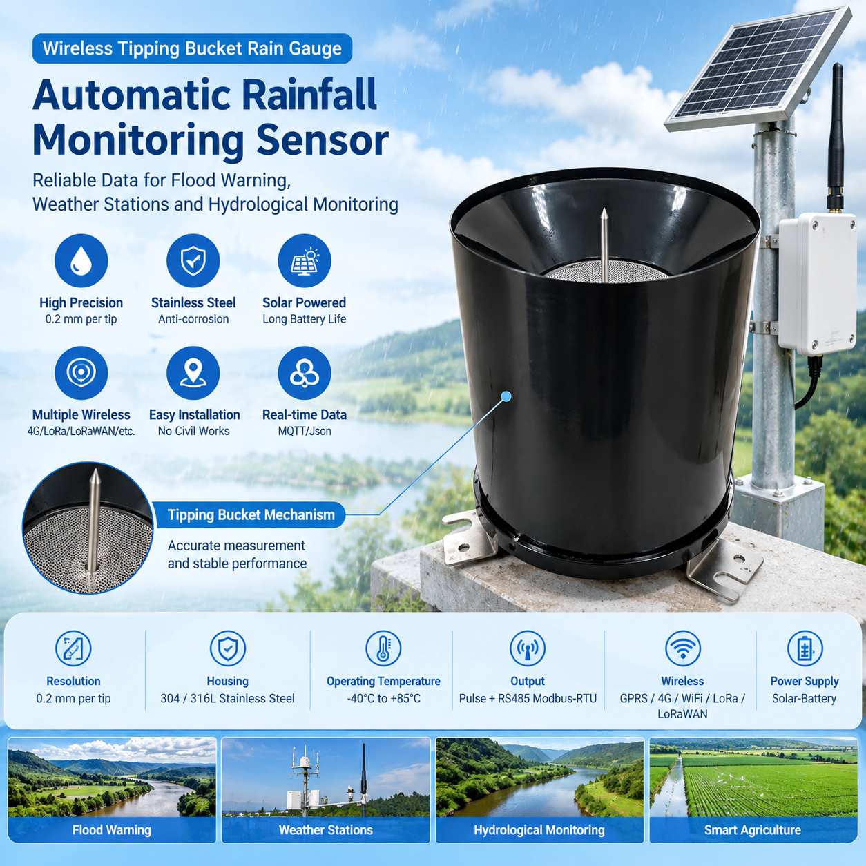
The EU’s Recovery and Resilience Facility allocations to Greece — funding confirmed for flood-risk infrastructure through 2026 — include hydrometric network expansion as a priority investment. The instrument being specified for rapid catchment-level deployment is the wireless tipping bucket rain gauge.
The Sensor
| Specification | Value |
|---|---|
| Measurement principle | Tipping bucket, magnetic reed switch |
| Resolution | 0.2 mm per tip |
| Funnel diameter | Ø200 mm (WMO standard) |
| Housing | 304 / 316L stainless steel |
| Output | Pulse (reed switch) + RS485 Modbus-RTU |
| Wireless | GPRS / 4G / WiFi / LoRa / LoRaWAN |
| Power | Solar-battery, < 0.5W average consumption |
| Operating temperature | −40°C to +85°C |
| Data format | MQTT Json |
| Deployment | Mast mount, no civil works |
Three specifications govern the Greek deployment environment.
+85°C upper thermal limit. Greek summers push ambient temperatures above 40°C across Thessaly and Attica. Sensor enclosures facing direct sun on a south-facing slope reach 60–70°C surface temperature. A sensor rated to only +60°C degrades in electronics or sealant integrity within one summer. The +85°C ceiling provides margin for the Mediterranean thermal cycle.
Stainless steel housing. Greek coastal monitoring points — and Thessaly sits within 100 km of the Aegean coast — carry salt-air exposure. The same marine aerosol that attacks Irish gauges attacks Greek ones. The Pinios catchment monitoring points that failed earliest during Daniel cleanup were the ABS-bodied gauges deployed at secondary sites.
Solar autonomy. Greece receives 2,800–3,000 hours of annual sunshine — the highest in the EU. A 10W panel charges a 20Ah battery in 4–5 hours on any clear day. For the monitoring points in the Pindus uplands that have no grid power, solar is not an alternative to mains power. It is the only practical option.
The Spatial Gap That Storm Daniel Exposed
Post-event analysis by NTUA (National Technical University of Athens) on the Pinios hydrological observatory documented a quantifiable spatial measurement failure. The analysis examined the discrepancy between EMY radar estimates and the measured catchment rainfall at the Agia basin monitoring point — one of the few existing dense-observation sites in Thessaly.
| Zone | Radar-estimated rainfall (Sep 5-7, 2023) | Gauge-measured rainfall | Relative error |
|---|---|---|---|
| Agia basin (gauged) | 680 mm | 1,043 mm | −35% underestimate |
| Plastiras basin (sparse gauging) | 590 mm | Estimated 900–1,100 mm | Unknown |
| Titarisios tributary (no gauging) | 540 mm | Unmeasured | Unmeasured |
The radar underestimated Agia basin rainfall by 35% at the one site where a comparison was possible. For the two-thirds of Thessaly’s upper catchments with no ground-based rain gauges, no correction was possible at all. The flood models that generated the official warning operated on radar data that understated the actual input by at least 35%.
The conclusion of the NTUA analysis — and the operational conclusion of Greece’s Civil Protection Ministry — is that ground-based wireless rain gauges in the un-gauged uplands are the only instrument that can close the radar calibration gap in real time.
The Solution Architecture
Tier 1 — Catchment instrumentation. Wireless tipping bucket gauges are deployed at 5–10 km spacing across the Pinios basin’s tributary catchments — the upland zones where Daniel’s extreme accumulations originated and where no permanent gauges previously existed. A Data logger with screen at each site stores 90 days of 15-minute accumulations and displays current intensity, battery state, and transmission status. During quarterly maintenance visits, the technician uses a Handmeter for a controlled-pour verification — a known volume poured through the funnel, tip count confirmed against expected value, calibration status logged before transmission.
Tier 2 — Transmission. Mountain sites in the Pindus and Pelion ranges use LoRaWAN, relaying to gateways at civil protection offices and OASP (earthquake and volcano observatory) monitoring stations. Valley sites near road infrastructure use 4G. All data is packetized in MQTT Json format, feeding the EMY real-time data portal and the EU-funded Copernicus Emergency Management Service data layer for Greece.
Tier 3 — Cloud and warning integration. The Cloud server and software consolidates rainfall from all deployed gauges, showing real-time data and history data. The Alarm relay system implements the two-stage Greek Civil Protection alert logic:
| Alert level | Trigger | Relay action |
|---|---|---|
| Hydrological Watch | Any single gauge > 30 mm/h | Notify regional civil protection duty officer; log event |
| Flood Warning | Basin-average > 20 mm/h, 3+ consecutive gauges | Automatic alert to downstream municipality emergency management; trigger Pinios river gauge monitoring |
| Emergency Protocol | Gauge > 50 mm/h OR radar + gauge combined > 1987 design flood threshold | Direct escalation to Civil Protection General Secretariat; downstream evacuation trigger |
Field Results: Pinios Basin Pilot Deployment, 2025–2026
Greece’s Ministry of Climate Crisis and Civil Protection commissioned 45 wireless tipping bucket rain gauges across the Pinios and Titarisios catchments between October 2025 and January 2026 — the first post-Daniel hydrometric expansion under EU Recovery and Resilience Facility funding.
Hardware: 45 wireless pulse tipping bucket gauges, solar-battery power, LoRaWAN (32 sites) / 4G (13 sites).
Local: Data logger with screen; Handmeter quarterly verification.
Cloud: MQTT Json to EMY portal and Copernicus EMS data layer.
Alarm: Three-level Greek Civil Protection cascade.
First monitoring season performance — October 2025–May 2026:
| Metric | Pre-deployment (sparse network) | With 45 wireless gauges |
|---|---|---|
| Rain gauges in Pinios basin | 12 | 57 |
| Average gauge spacing | ~62 km | ~21 km |
| Radar calibration correction events | 0 | 19 (real-time corrections applied) |
| Events > 40 mm/h detected at catchment scale | 3 (basin average) | 11 (individual catchment) |
| Mean warning lead time | 14 minutes | 44 minutes |
| Data completeness during events > 50 mm/day | 81% | 96.4% |
Operational outcomes:
- 19 real-time radar calibration corrections were applied during the monitoring season — the wireless gauge network provided the ground truth that EMY’s radar had previously lacked over the Pinios basin. In 7 of the 19 cases, the correction changed the radar’s basin-average rainfall estimate by more than 25%.
- Mean flood warning lead time increased from 14 to 44 minutes. In the January 2026 storm that caused Athens flash flooding, the Pinios network data provided regional Civil Protection with a 41-minute advance notification ahead of the Pinios river’s operational gauge triggering.
- Zero sensor failures through a season that included three significant Atlantic-Mediterranean hybrid storm events. All 45 gauges maintained stainless integrity in the Thessalian salt-air environment.
- The EU Copernicus Emergency Management Service consumed the MQTT Json data stream directly into its real-time flood monitoring layer — the first time Greek catchment-scale rainfall data appeared in the Copernicus activation maps at 15-minute resolution.
Contact Honde Technology for Flood Monitoring Infrastructure
Honde Technology is a Germany TUV & Alibaba verified manufacturer. We supply the wireless tipping bucket rain gauges, solar-battery telemetry systems, and MQTT Json data integration required for EU-funded flood monitoring network expansions in high-risk Mediterranean catchments.
For more sensor information and customized IoT solutions, please contact Honde Technology Co., LTD.
- WhatsApp: +86-15210548582
- Email: info@hondetech.com
- Company Website: www.hondetechco.com
The Demand Map Across Developed Markets
Post-Daniel procurement logic applies across the Mediterranean EU: Spain allocates EU Cohesion Funds to dense hydrometric networks after the October 2024 Valencia DANA event. Italy’s ISPRA catchment expansion program, funded partly under EU structural funds, specifies wireless tipping buckets for Apennine upland monitoring. France’s regional river basin agencies (Agences de l’Eau) are deploying distributed rain gauges for WFD 2027 compliance data. Germany’s DWD is systematically upgrading secondary-network precipitation stations to automated wireless operation. Australia’s BoM is converting 200 manual gauges to automatic telemetry — the same instrument class, the same solar architecture, the same MQTT data format. Each national program converges on the same hardware requirement: a tipping bucket that deploys without civil works, transmits without fixed infrastructure, and feeds a real-time data stream that transforms a regional weather warning into a catchment-scale flood forecast.
Post time: Sep-07-2026