

As extreme rainfall events continue to create serious risks in mountainous and riverine areas, rapid detection of rainfall, slope instability, rising water levels and abnormal flow conditions has become increasingly important. Flash floods can develop within minutes to several hours, making continuous local monitoring an essential part of an effective early warning system. The World Meteorological Organization (WMO) identifies intense rainfall and rainfall occurring on already saturated soils as major factors in flash-flood development.
To address these challenges, an integrated mountain flood, mudslide and rising-water early warning system can combine slope monitoring sensors, water-level monitoring, rainfall measurement, flow monitoring and local audible/visual alarms into one field-deployed solution.
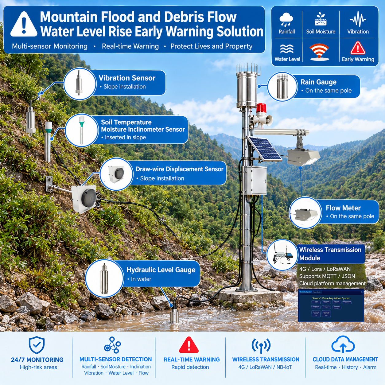
A Multi-Parameter Early Warning System for Mountain Disaster Monitoring
The proposed system is designed for mountain streams, flood-prone valleys, landslide areas, reservoirs, river channels, dams and other high-risk locations.
Instead of relying on a single parameter, the system monitors several environmental changes simultaneously:
- ✓ Slope temperature, humidity, tilt and soil conditions
- ✓ Ground vibration
- ✓ Pull-wire displacement
- ✓ Water level
- ✓ Rainfall
- ✓ Flow conditions
- ✓ Local audible and visual alarms
- ✓ Wireless data transmission and cloud monitoring
By combining these measurements, monitoring personnel can obtain a more complete picture of changing environmental conditions and establish warning rules according to local risk thresholds.
1. Slope Monitoring for Landslide and Mudslide Risk
Mountain slopes are often the first area where abnormal conditions appear before a landslide or debris-flow event. The system places multiple sensors directly on or inside the slope to continuously observe changes in the surrounding environment.
Temperature, Humidity, Tilt and Soil Sensor
A multi-parameter sensor can be installed directly into the mountain slope to monitor:
- Soil conditions
- Temperature
- Humidity
- Ground inclination
- Changes in slope conditions
Vibration Sensor
A vibration sensor is installed on the slope to detect abnormal ground vibration, including rock movement, slope disturbance, ground vibration, potential instability, and abnormal mechanical activity.
Pull-Wire Displacement Sensor
Pull-wire displacement sensors can be installed at selected monitoring points along the slope. When the monitored area moves, the displacement sensor detects changes in position and transmits the corresponding measurement. Multiple displacement monitoring points can be arranged across a slope to help identify localized deformation and progressive movement.
2. Water-Level Monitoring in Mountain Rivers and Streams
At the river or mountain stream, a hydraulic water-level sensor can be installed in the water. Continuous water-level monitoring can provide real-time information about rapid water-level rise, river level changes, flash-flood development, water-level threshold conditions, and abnormal fluctuations.
3. Rainfall Monitoring with a Tipping-Bucket Rain Gauge
A tipping-bucket rain gauge is installed on the monitoring mast to measure local precipitation, helping determine rainfall intensity, accumulated rainfall, threshold conditions, and potential correlation between rainfall and river-level rise.
4. Flow Monitoring for Real-Time River Conditions
A flow meter can be installed near the monitoring point. Combining Rainfall + Water Level + Flow provides a comprehensive picture of changing hydrological conditions.
5. Audible and Visual Alarm for On-Site Warning
When monitoring parameters reach predefined warning thresholds, the system can activate a local audible and visual alarm. A typical warning sequence can be configured around different risk levels: Normal → Attention → Warning → Emergency.
6. Wireless Data Transmission and Remote Monitoring
Field sensors can transmit monitoring data through wireless modules (4G, LoRa, LoRaWAN, MQTT, JSON) to a cloud platform. A typical data flow: Field Sensors → Monitoring Controller → Wireless Communication → Cloud Platform → Monitoring Center.
7. How the Mountain Flood Early Warning System Works
Layer 1: Slope
Temp / Humidity / Tilt / Soil + Vibration + Pull-Wire Sensors
Layer 2: Hydrological
Water-Level Sensor + Rain Gauge + Flow Meter
Layer 3: Local Warning
Audible & Visual Alarm
Layer 4: Remote
4G / LoRa / LoRaWAN / MQTT / Cloud Platform
Contact Information
Company Name: Honde Technology Co., Ltd.
Website: www.hondetechco.com
Email: info@hondetech.com
Post time: Sep-24-2026