
The June Monsoon Crisis: Why Standard Hydrometry Fails in Mountain Gorges
As of June 2026, the monsoon season has officially made landfall across Southeast Asia (particularly Vietnam’s northern highlands, Thailand, and the Philippines) and South Asia (India and Nepal). During this season, small and medium-sized mountain rivers undergo “flash” events—surging from ankle-deep streams to violent torrents in under 15 minutes.
These events present two severe challenges to traditional hydrology systems:
- Debris and Silt Destruction: Submerged pressure transducers or ultrasonic Doppler sensors are regularly smashed by floating tree trunks or buried under heavy sediment during the first hour of a storm.
- Secondary Hazards (Landslides): Heavy rainfall doesn’t just fill rivers; it saturates mountainous slopes, triggering devastating mudslides and landslides that block rivers, creating temporary “dams” that subsequently burst.
To survive these conditions, modern civil engineering requires non-contact sensing coupled with slope stability tracking to form a unified defense network.
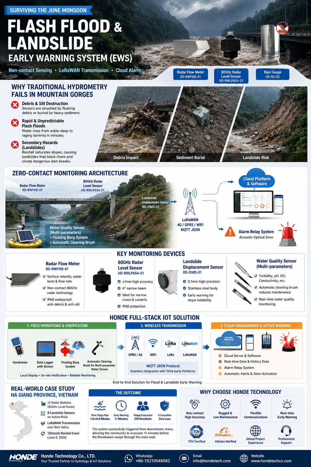
The Perception Layer: Non-Contact Radar and Slope Stability
Honde Technology’s Mountain Torrent Warning System is built on a “zero-contact” engineering philosophy. The system consists of three critical hardware pillars deployed above the danger zone:
1. The 3-in-1 Radar Flow Meter (RD-RWFMS-01)
Installed on bridge decks or cantilever steel arms, this unit combines Surface Velocity, Water Level, and Flow Rate calculations into a single IP68 enclosure. It operates entirely in the “air gap” above the flood stage, completely immune to floating debris, silt, and rapid currents.
2. The 80GHz High-Precision Level Radar (HD-RWLP654-01)
For narrow gorges or deep concrete culverts, our 80GHz millimeter-wave radar provides a focused 6° beam angle. This narrow beam ignores bridge pillars, overhanging tree branches, and wall reflections, tracking water levels with ±1mm precision even during turbulent surges.
3. Slope Displacement Sensors (RD-DWD-01)
To monitor the landslide risk that precedes river blockages, our heavy-duty wire-draw displacement sensors are anchored to vulnerable rock faces. They detect micro-movements down to 0.1mm, sending out alerts before a major slope failure occurs.
4. The Ecological Safeguard: Multi-Parameter Water Quality
Flash floods often flush agricultural runoff, sewage, and industrial chemicals into the river system. By deploying our conventional electrochemical probes (Turbidity, pH, and DO), operators can multiply the real-time discharge flow rate by the pollutant concentration to calculate the Pollutant Flux in real-time—a critical tool for tracing contamination sources after a flood event.
The Honde Full-Stack Solutions Architecture
In remote mountain terrains, a sensor without communication is useless. We integrate our hydrology hardware into a robust, three-tiered operational framework:
1 Local Field Operations & Verification
- Handmeter & On-Site Data Loggers: Field technicians are equipped with our Handmeter for quick calibration checks.
- Local Logging Terminal: Stations are anchored by our Data Logger with screen, allowing local operators to view real-time levels and 30-day graphical trends directly on-site, even during cellular outages.
- Deep Water & Estuary Setup: For downstream reservoirs or wide river mouths, the Floating Buoy system is utilized to keep the Automatic cleaning brush for multi-parameter water sensor active, ensuring bio-fouling and sediment do not compromise water quality readings.
2 The Wireless Backbone (Transmission)
- Multi-Protocol Compatibility: Our stations support GPRS/4G/WIFI/LORA/LORAWAN wireless modules.
- Digital Native Protocol: To ensure compatibility with national emergency response systems, the modules support the MQTT Json format. This allows the sensor data to be ingested directly by third-party Digital Twin and hydraulic modeling platforms without custom middleware or licensing fees.
3 Cloud Management & Active Warning
- All data is centralized on the Cloud server and software, offering 24/7 visualization of rainfall (using our 304 stainless steel tipping-bucket gauges), river stage, and slope movement.
- The Alarm Relay System: This is the critical life-saving loop. When the 80GHz radar detects water crossing the critical “evacuation threshold,” or when the displacement sensor detects slope movement, the platform triggers an Alarm Relay system to see the real time data, history data, and automatically activates high-decibel Acoustic-Optical sirens in downstream villages—bypassing cellular networks to warn residents instantly.
Real-World Case Study: Mountain Torrent EWS in Ha Giang Province, Vietnam
Ha Giang, a mountainous province in northern Vietnam, experiences severe flash floods and landslides during the June monsoon. The local department of agriculture required a system that could survive violent storms and provide a 15-minute evacuation window for downstream communities.
The Solution Deployment:
Sourcing and Hydrological Project Support
For more sensor information and customized IoT solutions, please contact Honde Technology Co., LTD.
Post time: Jun-10-2026