

California’s Sustainable Groundwater Management Act (SGMA) has changed the way groundwater agencies think about monitoring.
The goal is not simply to know how deep the groundwater is today.
The bigger question is:
How is groundwater changing between measurements—and can that change be detected early enough to support sustainable management?
California’s Department of Water Resources (DWR) identifies 94 medium- and high-priority groundwater basins and subbasins subject to SGMA requirements, including 21 critically overdrafted basins. These areas represent a substantial share of the state’s groundwater pumping, population and irrigated agriculture.
SGMA requires local groundwater sustainability agencies (GSAs) to develop and implement groundwater sustainability plans, with the overall objective of achieving groundwater sustainability within 20 years.
That creates a growing need for something more valuable than occasional groundwater measurements:
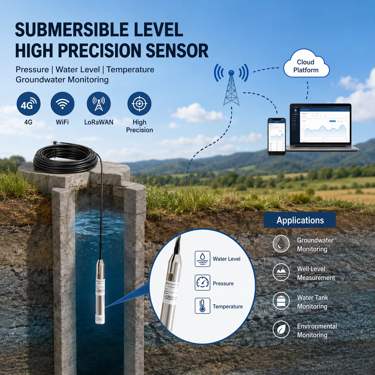
This is where GPRS/4G submersible level sensors can transform a traditional monitoring well into an automated IoT groundwater monitoring station.
Traditional groundwater measurement often depends heavily on field technicians visiting monitoring wells and manually recording depth-to-water.
The workflow is simple:
The problem is not that the measurement is inaccurate.
The problem is what happens between measurements.
Consider a monitoring well measured only twice a year:
Groundwater Level
      │
      │       ●
      │
      │
      │                  ●
      │
      └────────────────────────── Time
              6 Months
Two points can show where groundwater was.
They do not necessarily show:
- when the decline started;
- how quickly the decline occurred;
- when pumping pressure increased;
- whether neighboring wells began interfering;
- when a critical threshold was crossed;
- how long the aquifer took to recover.
A continuous monitoring system changes the data from snapshots to a trend.
The difference is not simply automation. It creates a completely different type of groundwater dataset.
| Monitoring Method | Manual Measurement | Automated IoT Monitoring |
|---|---|---|
| Measurement frequency | Periodic | 15 min–1 hour configurable |
| Field visit required | Yes | Only for verification/maintenance |
| Real-time data | ✕ | ✓ |
| Historical trend | Limited | ✓ Continuous |
| Remote monitoring | ✕ | ✓ |
| Automated alarm | Limited | ✓ |
| Communication | Manual upload | GPRS/4G/LoRaWAN |
| Local data storage | Optional | Data logger available |
| Cloud integration | Manual | MQTT JSON |
| Suitable for large networks | Labor intensive | Highly scalable |
Honde’s submersible level sensor is designed to convert a conventional monitoring well into an automated groundwater observation point.
A 316L stainless steel pressure sensor is installed below the expected seasonal water-level range.
The sensor measures hydrostatic pressure and converts it into water-level information.
Depending on the configuration, the system can provide:
This makes it suitable for:
| Parameter | Honde Submersible Level Sensor |
|---|---|
| Measurement Principle | Hydrostatic Pressure |
| Accuracy | ±0.1% FS |
| Resolution | Up to 1 mm |
| Housing | 316L Stainless Steel |
| Protection | IP68 |
| Depth Range | 10–200 m configurations |
| Wired Output | RS485 Modbus-RTU / 4–20 mA |
| Wireless Options | GPRS / 4G / WiFi / LoRa / LoRaWAN |
| Power | 12 VDC / Solar-Battery System |
| Data Format | MQTT JSON |
| Installation | Submersible / Fixed-depth Well Installation |
For long-term groundwater monitoring, the sensor may remain submerged for months or years.
The 316L stainless-steel housing provides a robust mechanical enclosure for continuous deployment in demanding monitoring environments.
A scalable groundwater monitoring station can be divided into three layers.
The submersible pressure sensor is installed at a fixed depth inside the monitoring well.
It continuously measures hydrostatic pressure and calculates the corresponding water level.
A data logger with screen can display:
- Current water level
- Historical trend
- Battery status
- Communication status
- Sensor status
During scheduled field inspections, technicians can use a Handmeter / electronic water-level tape to perform reference verification.
The sensor or data logger can transmit groundwater data through multiple communication options.
This flexibility allows the same sensor platform to be adapted to different groundwater networks.
Once data reaches the cloud platform, operators can monitor an entire groundwater network from one interface.
┌─────────────────────────────────────────┐
│       GROUNDWATER MONITORING            │
├─────────────────────────────────────────┤
│ Well 01     18.42 m       NORMAL        │
│ Well 02     22.16 m       NORMAL        │
│ Well 03     31.85 m       ↓ ALERT       │
│ Well 04     15.73 m       NORMAL        │
│ Well 05     27.42 m       ↓ RAPID DROP  │
└─────────────────────────────────────────┘
The platform can combine:
This changes groundwater monitoring from a collection of individual wells into a connected groundwater network.
A groundwater level alone tells only part of the story.
For drought management, the rate of change can be equally important.
For example:
Water Level
  │
  │ ●
  │  \
  │   \
  │    \
  │     \
  │      ●
  │       \
  │        ●  ← Rapid Decline
  │
  └────────────────────── Time
A cloud platform can calculate:
and trigger an alarm when the decline exceeds a predefined threshold.
This creates a more proactive management model:
instead of:
This is one of the strongest product-conversion messages for the article.
| Sampling Interval | Measurements / Day | Measurements / Year |
|---|---|---|
| Semi-annual | — | 2 |
| Daily | 1 | 365 |
| Hourly | 24 | 8,760 |
| 30 minutes | 48 | 17,520 |
| 15 minutes | 96 | 35,040 |
One monitoring well can become a 24/7 groundwater data source instead of a twice-a-year snapshot.
DWR’s SGMA framework emphasizes groundwater sustainability planning, monitoring, reporting and assessment. DWR provides groundwater datasets and tools specifically to support sustainable groundwater management decisions.
For GSAs and their technical consultants, continuous monitoring can provide additional evidence for understanding:
The following chart concept illustrates the difference between periodic measurement and continuous monitoring.
| Month | Manual Snapshot | Automated Monitoring Trend |
|---|---|---|
| January | ● | ●●●●●●● |
| February | — | ●●●●●●● |
| March | — | ●●●●●●● |
| April | — | ●●●●●●● |
| May | — | ●●●●●●● |
| June | ● | ●●●●●●● |
Manual system: knows the water level at two moments.
Automated system: sees the entire trajectory.
The sensor itself is only the first component.
For a professional groundwater monitoring project, Honde can combine multiple components into one solution.
| Component | Purpose |
|---|---|
| Submersible Level Sensor | Continuous water-level measurement |
| Data Logger with Screen | Local display & storage |
| Handmeter | Field reference verification |
| GPRS/4G Module | Cellular telemetry |
| LoRaWAN Module | Low-power remote communication |
| Solar + Battery | Off-grid power |
| Cloud Server & Software | Real-time & historical monitoring |
| Alarm Relay System | Threshold and event alerts |
       MONITORING WELL
             │
             ▼
   ┌───────────────────┐
   │ Submersible Level │
   │      Sensor       │
   └─────────┬─────────┘
             │
             ▼
   ┌───────────────────┐
   │ Data Logger + LCD │
   └─────────┬─────────┘
             │
      ┌──────┴──────┐
      ▼             ▼
    4G/GPRS      LoRaWAN
      │             │
      └──────┬──────┘
             ▼
      Cloud Platform
             │
    ┌────────┼────────┐
    ▼        ▼        ▼
 Dashboard  History  Alarm
For groundwater agencies managing dozens or hundreds of monitoring wells, labor efficiency becomes an important part of the business case.
Instead of sending technicians to every well for every measurement:
The field team can focus on wells that actually require attention.
| Item | Manual Network | Automated Network |
|---|---|---|
| Routine measurement | Field visit | Remote |
| Data collection | Manual | Automatic |
| Trend detection | Periodic | Continuous |
| Alarm detection | Manual review | Automatic |
| Field work | Broad coverage | Targeted |
| Historical dataset | Sparse | Dense |
| Multi-well management | Difficult | Centralized |
Automation does not eliminate field verification. It makes field verification smarter.
Many monitoring wells are located far from offices, power infrastructure and reliable communications.
This is why the system can be configured with:
This is particularly valuable for large agricultural and groundwater basins where monitoring points can be widely distributed.
The opportunity extends beyond California.
The common requirement is increasingly clear:
Reliable submersible measurement + remote telemetry + centralized data management.
For distributors, environmental engineering companies and system integrators, selling only a pressure sensor creates limited project value.
A stronger proposition is:
This allows one monitoring point to become a complete IoT node.
And a network of 50, 100 or 500 wells becomes a scalable groundwater monitoring platform.
| Requirement | Honde Solution |
|---|---|
| Continuous groundwater level | Submersible pressure sensor |
| High-resolution measurement | Up to 1 mm resolution |
| Long-term deployment | 316L stainless steel + IP68 |
| Remote monitoring | GPRS / 4G / LoRaWAN |
| Industrial integration | RS485 Modbus-RTU / 4–20 mA |
| Local data | Data Logger with Screen |
| Field verification | Handmeter |
| Off-grid monitoring | Solar + Battery |
| Cloud integration | MQTT JSON |
| Historical analysis | Cloud Software |
| Threshold alarm | Alarm Relay System |
| Multi-well deployment | Supported |
| OEM / project customization | Available |
The future of groundwater management is not simply about collecting more measurements.
It is about collecting better data at the right time.
A conventional monitoring well provides a reading.
An automated monitoring well can provide:
Together, these capabilities turn a passive monitoring point into an active groundwater management node.
California’s SGMA framework has made groundwater monitoring a long-term management priority, particularly in medium- and high-priority basins and critically overdrafted areas. DWR’s current basin prioritization identifies 94 medium- and high-priority basins/subbasins, including 21 critically overdrafted basins.
For these networks, the next step is not necessarily more manual measurements.
It is continuous, connected and traceable groundwater data.
A Honde submersible level sensor can provide the foundation:
Honde Technology provides customizable groundwater monitoring solutions combining:
For groundwater sustainability programs, agricultural water management, aquifer monitoring and large-scale environmental monitoring projects, Honde Technology can customize the sensor range, communication method, installation depth and cloud architecture according to project requirements.
Website: www.hondetechco.com
Email: info@hondetech.com
WhatsApp: +86-15210548582
Post time: Aug-18-2026