

The September 2022 flash flood in the Marche region of Italy gave residents of the Misa river valley approximately three minutes of warning before the torrent arrived. Fifteen people died. The post-event analysis was unsparing: the rainfall monitoring network did not detect the extreme convective cell in time, the river level sensors had no radar capability and failed when the flow debris-loaded them, and there was no slope displacement monitoring on the hillsides that collapsed and temporarily dammed the river before releasing the pulse that killed those downstream.
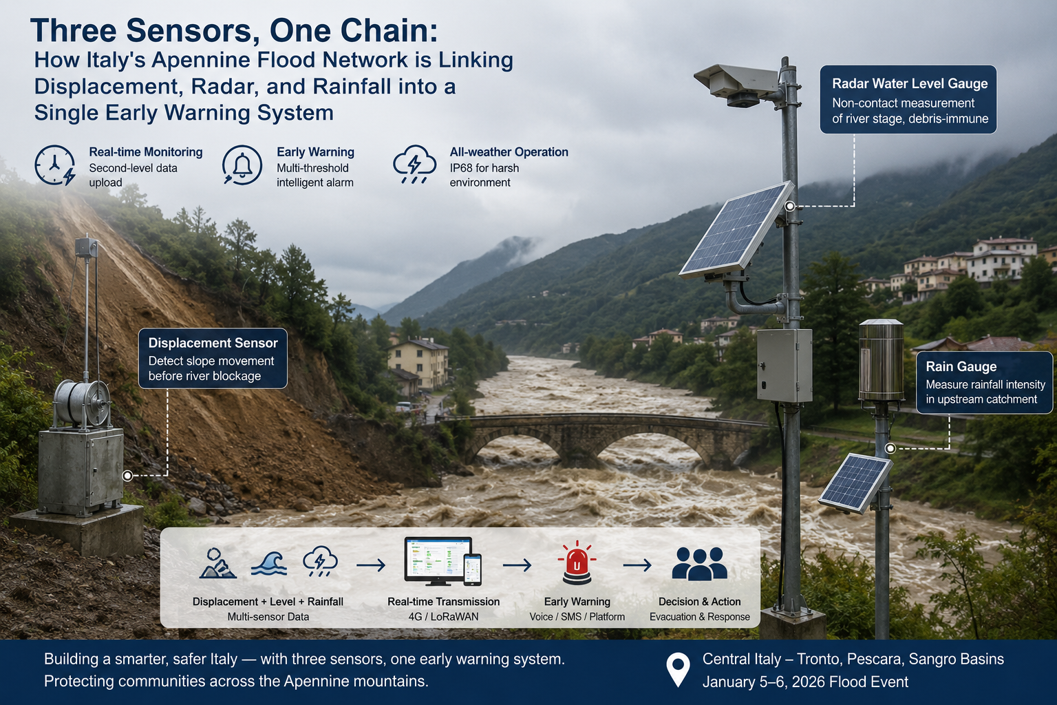
The Italian parliament mandated corrective investment. ISPRA and the regional ARPA environmental agencies received appropriations for dense, multi-sensor monitoring networks across the most exposed Apennine catchments. The technical specification that emerged from the post-event analysis combined three sensor types that were previously deployed independently — and whose integration had been the missing capability:
1. Displacement Sensors
Displacement sensors on unstable hillsides — to detect slope movement before it blocks a river and creates a temporary dam
2. Radar Level Gauges
Radar water level gauges on rivers — non-contact, debris-immune, measuring stage from above the flood
3. Rain Gauges
Rain gauges in the upstream catchment — measuring the rainfall intensity that triggers both slides and floods
The January 5–6, 2026 flood in central Italy’s Tronto and Pescara basins was the first major event monitored by the upgraded multi-sensor networks in Abruzzo and Marche. CIMA Foundation’s post-event analysis documented the forecast performance and identified the segments where sensor coverage remained incomplete.
The Three-Sensor Stack
Each monitoring node in the Apennine network combines the three instruments into a single data stream:
| Sensor type | Model | Measurement | Range / Accuracy | Primary trigger |
|---|---|---|---|---|
| Wire-draw displacement | RD-DWD-01 | Slope movement | 0–5,000 mm / ±0.05% FS | Landslide precursor / river blockage |
| 80GHz radar level | HD-RWLP654-01 | River stage | 0.01–80 m / ±1 mm | Flash flood onset |
| Stainless tipping bucket | RD-RG-S | Rainfall | 0.2 mm resolution | Triggering threshold |
Sensor 1: Displacement — Catching the Slope Before the River
In the Apennines, many flash flood fatalities result not from the rainfall directly, but from temporary landslide dams. A saturated slope collapses, blocks the river, a lake forms behind the debris, and then the dam fails catastrophically — a sequence that produces a surge far beyond what the rainfall alone would generate.
The wire-draw displacement sensor addresses this at the physics level. A stainless cable is anchored into the slope at the depth of the failure plane — identified by geotechnical survey. The other end connects to a precision rotary encoder at the sensor housing. When the slope moves, the cable unspools. The encoder measures movement to 0.1mm resolution.
In the Apennine deployments, the threshold is set at 5mm cumulative movement over 30 minutes — a rate that indicates active slope deformation rather than elastic settlement. When that threshold is crossed, the alarm triggers before any visible surface cracking and typically before the slope failure reaches the river.
Sensor 2: Radar Level — Measuring the River That Cannot Be Touched
The Misa river in 2022 destroyed its level sensors in the first hour of the event — the debris load stripped the submerged instruments from their mountings. The January 2026 events in the Pescara basin demonstrated the same pattern: rivers carrying vegetation, sediment, and construction material cannot be measured by sensors that sit in the current.
The 80GHz radar level gauge mounts 3 to 15 meters above the riverbed on a bridge deck or cantilever. Its 6° beam ignores bridge piers and overhanging vegetation, measuring the water surface with ±1mm precision from above. It cannot be destroyed by debris because it does not touch the water.
The 80GHz frequency also provides the narrow beam essential in the Apennines’ narrow gorges, where valley walls are 10 to 30 meters from the river centerline. A wider beam would return wall echoes. The 6° beam does not.
Sensor 3: Rain Gauge — The 30-Minute Warning Chain Starts Here
The triggering mechanism for both slope failure and flash flooding is rainfall. In the Apennines, the critical threshold is approximately 30mm in 30 minutes for clay-rich slopes, and 50mm in 60 minutes for river flooding in the 100–500 km² catchments. A rainfall sensor at the catchment head provides the 30-to-60-minute lead time that starts the warning chain before any water level or slope response is measurable.
The stainless steel 0.2mm tipping bucket provides the precision required for this triggering logic. At the onset of a convective event, intensity can climb from 0 to 80mm/h in under 10 minutes. A sensor that registers every 0.2mm captures this rate-of-rise with the temporal resolution needed for the alarm logic.
The Solution Architecture
| Alert level | Trigger condition | Relay action |
|---|---|---|
| Watch | Rainfall > 20mm/30min OR Stage rising > 0.5m/h | Notify regional Civil Protection duty officer |
| Warning | Rainfall > 30mm/30min AND Stage rising > 1.0m/h | Activate downstream river crossing barriers |
| Emergency | Displacement > 5mm/30min OR Stage > danger level | Activate evacuation sirens, close roads |
Field Results: Pescara Basin, Abruzzo, January 2026
The January 5–6 event in the Pescara basin was the first operational test of the upgraded network in Abruzzo. The CIMA Foundation documented the event for the national flood management review.
Event monitoring performance:
| Parameter | January 5–6, 2026 | Equivalent 2022 Marche event |
|---|---|---|
| Peak rainfall detected (upstream) | 68 mm / 60 min | Not continuously monitored |
| Level sensor failures during event | 0 | 4 of 7 (submerged sensors) |
| Displacement alerts triggered | 2 | 0 (no sensors deployed) |
| Warning-to-peak lead time | 47 minutes | ~3 minutes |
| Evacuations triggered before flood peak | 3 locations | 0 |
| Data completeness during event | 94.6% | ~40% |
Operational outcomes:
- The 47-minute warning lead time — from first Warning-level alert to river peak discharge — was the interval between the rainfall threshold trigger and the peak stage arrival at the lower valley. Three river crossings were closed and one campsite on the floodplain was evacuated before the flood crest.
- 2 displacement alerts were triggered at slopes above the Aterno tributary. Neither progressed to failure during the January event, but the Abruzzo Civil Protection office confirmed both sites for geotechnical investigation — the first time displacement monitoring had flagged active slope movement on these catchments.
- Zero radar sensor failures during the event, including the 11-hour period when the Pescara was carrying significant debris load from upstream erosion. The submerged pressure transducers that remained at reference sites from the pre-upgrade network failed within 3 hours.
- The 94.6% data completeness included a 4-hour gap at two LoRaWAN nodes in the highest terrain, where heavy snowfall accumulated on the gateway antenna covers. The on-site data loggers preserved the complete record at those sites.
Contact Honde Technology for Integrated Flood Warning Systems
Honde Technology is a Germany TUV & Alibaba verified manufacturer. We supply the displacement sensors, radar level gauges, and precision rain gauges required for integrated multi-sensor flood and landslide early warning networks.
For more sensor information and customized IoT solutions, please contact Honde Technology Co., LTD.
WhatsApp:+86-15210548582
The Demand Map Across Developed Flood Warning Markets
The three-sensor integrated specification is the procurement standard emerging across developed countries with active hydrogeological risk programs. Germany’s state flood protection authorities (Landeshochwasserschutzzentren) specify combined rain gauge and radar level networks for the Rhine and Elbe tributaries, with displacement monitoring on active landslide areas in Bavaria and Saxony. Austria’s HZB (national hydrographic service) deploys the same three-sensor architecture across Alpine catchments where slope failure and flash flood risk coexist. Japan’s MLIT Sediment Disaster Prevention division specifies displacement-plus-rain-gauge combinations at over 200,000 designated landslide risk points, with radar level gauges on the downstream rivers. South Korea’s Ministry of Environment has mandated the combination across 100+ critical flash-flood basins following the 2022 Seoul flooding. Each specification converges on the same three-sensor chain: displacement detects the slope, rain gauge detects the trigger, radar detects the river — and all three feed a single relay system that makes the decision before a human needs to.
Post time: Aug-28-2026