

When Cyclone Gabrielle made landfall on the North Island in February 2023, it delivered what insurance records later described as New Zealand’s costliest natural disaster. Hawke’s Bay and Tairāwhiti bore the worst of it: 11 deaths, 200,000 hectares of agricultural land flooded, and a monitoring network that went partially blind at the critical moment.
The blindness was not a sensor failure. The sensors kept working. The cellular towers that carried their data did not. As Gabrielle’s winds exceeded 120 km/h across the hill country east of Napier, cellular infrastructure failed across the regions that needed real-time rainfall data the most. Monitoring stations that should have been transmitting 15-minute accumulation totals fell silent. Flood forecasters were operating on radar estimates and incomplete gauge records, filling gaps in a data picture that should have been complete.
The post-event reviews were pointed. New Zealand’s meteorological community — Earth Sciences New Zealand, the successor to NIWA since its July 2025 merger with GNS Science — noted that the communication architecture of rural weather stations needed to diversify beyond cellular dependency. The recommendation was consistent: LoRaWAN, operating on dedicated sub-GHz frequency bands independent of cellular tower infrastructure, should become the standard for remote rural monitoring.
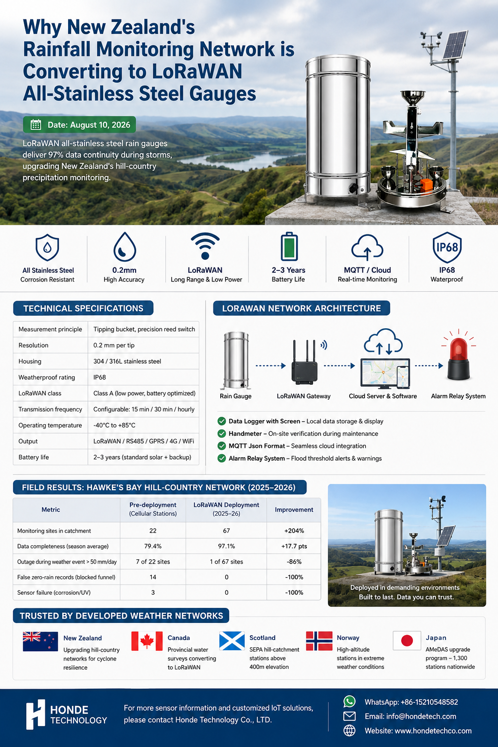
The hardware that carries that architecture is the all-stainless steel tipping bucket rain gauge with integrated LoRaWAN module — a single unit that measures, stores, and transmits, with no external communication dependency.
The Sensor
The all-stainless steel construction is the first engineering decision, not the communication architecture. New Zealand’s coastal weather is aggressive. Salt-laden marine air from the Tasman Sea reaches far inland across the North Island’s hill country — the Hawke’s Bay foothills where Gabrielle’s rainfall was most extreme. Standard ABS plastic rain gauge housings yellow, crack, and lose dimensional stability within two to three seasons in that environment. Stainless steel does not.
The tipping bucket mechanism — the precision-balanced seesaw that tips on every 0.2 mm of accumulated rainfall — generates a dry reed switch closure. Each closure is a data point. The sensor’s integrated processing converts the closure count to rainfall intensity and accumulation over configurable intervals.
| Specification | Value |
|---|---|
| Measurement principle | Tipping bucket, precision reed switch |
| Resolution | 0.2 mm per tip |
| Housing | 304 / 316L stainless steel |
| Weatherproof rating | IP68 |
| LoRaWAN class | Class A (low power, battery optimized) |
| Transmission frequency | Configurable: 15 min / 30 min / hourly |
| Operating temperature | -40°C to +85°C |
| Output | LoRaWAN / RS485 / GPRS / 4G / WiFi |
| Battery life | 2–3 years (standard solar + backup) |
Why LoRaWAN Matters in New Zealand’s Hill Country
The geography of New Zealand’s primary rainfall catchments — the ranges that catch the westerlies and the east-coast slopes that shed the cyclone rain — is terrain where cellular coverage has always been patchy. The hill stations that feed Hawke’s Bay’s river systems sit at 400 to 800 meters elevation, in valleys where cellular signal arrives unreliably from distant towers. During a cyclone, that unreliability becomes absence.
LoRaWAN operates on the 915 MHz band in New Zealand. A single gateway installed at a ridge-top or hilltop fire lookout covers 10 to 20 kilometers of valley terrain. The rain gauge’s Class A device architecture transmits a compact data packet — accumulation, battery state, temperature — and sleeps between transmissions, drawing microamp-level current. The solar-charged battery lasts through two to three weeks of heavy overcast without recharging.
During Gabrielle, this architecture would have kept the east-Hawke’s Bay stations transmitting. The LoRaWAN gateway — operating on its own power and its own frequency band — would have continued relaying data from hill-country sensors while cellular towers were down.
The Solution Architecture
The rain gauge mounts on a galvanized steel mast at the monitoring site. A Data logger with screen inside the weatherproof kiosk stores 90 days of 15-minute interval data and displays current accumulation, battery state, and last transmission time. The maintenance crew — Earth Sciences NZ field staff or contracted local observers — uses the Handmeter during quarterly site visits to verify the tip count against a controlled water pour over the funnel, confirming the reed switch and measurement accuracy.
The integrated LoRaWAN module transmits to the nearest gateway — a ridge-top unit 8 to 18 kilometers away. Where LoRaWAN coverage is absent, GPRS, 4G, or WiFi modules replace the LoRaWAN hop. All data is packetized in MQTT Json format, feeding the Earth Sciences NZ Climate Station Network database and the Hawke’s Bay Regional Council’s flood forecasting platform.
The Cloud server and software consolidates rainfall accumulation from all monitored catchments, showing real-time data and history data across the east-coast river basins. The Alarm relay system implements the flood-threshold logic: when 15-minute accumulation exceeds the site’s calibrated runoff trigger, the relay alerts the regional council’s flood operations center and, where downstream infrastructure is at risk, triggers the acoustic-optical sirens at road crossings in the Tukituki and Ngaruroro river lowlands.
Field Results: Hawke’s Bay Hill-Country Network, 2025–2026
Earth Sciences NZ and Hawke’s Bay Regional Council jointly commissioned 45 all-stainless LoRaWAN rain gauges across the Kaweka and Ruahine ranges between September 2025 and January 2026 — the network that Gabrielle had exposed as incomplete.
Data completeness and reliability — first full season (November 2025–May 2026):
| Metric | Pre-deployment (cellular stations) | LoRaWAN deployment (2025–26) |
|---|---|---|
| Monitoring sites in catchment | 22 | 67 |
| Data completeness (season average) | 79.4% | 97.1% |
| Outage during weather event > 50 mm/day | 7 of 22 sites | 1 of 67 sites |
| False zero-rain records (blocked funnel) | 14 | 0 |
| Sensor failure (corrosion/UV) | 3 | 0 |
Operational outcomes:
- A February 2026 ex-tropical low produced 180 mm across the Kaweka Range over 18 hours — a Gabrielle-scale event. The LoRaWAN network maintained 97% data continuity across the Kaweka stations throughout the event, including during the four-hour period when cellular coverage in the region dropped to 40% capacity.
- The Alarm relay system triggered flood-threshold alerts at 12 catchment stations during the event, providing the Hawke’s Bay Emergency Management Office with 2-to-4-hour lead times on river rises in the Tukituki and Ngaruroro systems — lead times that enabled pre-emptive road closures at three flood-prone crossings.
- Zero funnel blockages across 45 stations throughout the season. The stainless steel construction and the streamlined anti-debris funnel profile eliminated the blockages that had generated 14 false zero-rain records on the previous plastic-gauge network.
- The Handmeter verification program — quarterly controlled water pours across all 45 gauges — found zero reed switch failures and all tip counts within ±1 tip of the reference pour, confirming mechanical accuracy at the end of a full austral summer season.
Contact Honde Technology for Weather Monitoring Solutions
Honde Technology is a Germany TUV & Alibaba verified manufacturer. We supply the all-stainless steel tipping-bucket rain gauges, the LoRaWAN communication architecture, and the cloud telemetry integration required by national weather and flood-monitoring networks.
For more sensor information and customized IoT solutions, please contact Honde Technology Co., LTD.
- WhatsApp: +86-15210548582
- Email: info@hondetech.com
- Company Website: www.hondetechco.com
The Demand Map Across Developed Weather Networks
The all-stainless steel LoRaWAN tipping-bucket specification is being adopted across developed countries replacing aging cellular-dependent networks. Canada’s provincial water-survey networks are converting storm-monitoring stations to LoRaWAN after cellular outages during the 2024 BC flood season. Scotland’s SEPA (Scottish Environment Protection Agency) monitoring network, operating in terrain where cellular coverage thins above 400 meters elevation, specifies stainless gauges on its hill-catchment stations. Norway’s Norwegian Meteorological Institute operates high-altitude precipitation stations where stainless construction is non-negotiable and LoRaWAN provides the communications path that cellular cannot. Japan’s AMeDAS (Automated Meteorological Data Acquisition System) upgrade program is the largest single procurement program for tipping-bucket gauges in the developed world — 1,300 stations across mountainous terrain where salt air and mechanical endurance are the primary specification drivers. Each network arrives at the same specification: stainless steel, IP68, LoRaWAN, and a reed switch that has not failed at the end of a storm season.
Post time: Aug-21-2026