

The most dangerous measurement in hydrology is the one that has to be taken during a flood. Not from the gage house, not from the telemetry — the calibration measurement, the one that anchors the rating curve, the one that converts water level into discharge. Someone has to physically measure how fast the water is moving at the moment it is at its most violent.
In the United States, that someone is a USGS hydrographer. The agency visits approximately 8,000 streamgages every six weeks and makes high-flow discharge measurements when storms arrive. The historical method is wading: a hydrographer in a wetsuit and life vest walks into the river with a wading rod, a Price AA mechanical current meter, and a cable reel, measuring velocity at intervals across the channel. The method works. It is also how hydrographers have died — swept downstream by a surge, caught by a foot, pinned against a bridge pier.
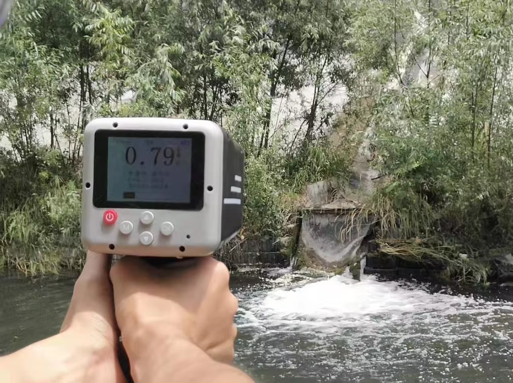
The replacement technology is a box the size of a large drill, pointed at the water from the bridge deck: the 24GHz Doppler handheld radar velocity meter. It measures surface velocity without contact, in seconds, from a position of safety. In 2026, this device is no longer a novelty in developed-country hydrometry. It is the standard tool being adopted by the agencies that can no longer justify putting employees in the water.
What the Device Actually Does
The Honde handheld radar flow meter emits a 24GHz microwave beam at the water surface and measures the Doppler frequency shift of the reflected signal. The shift is proportional to the surface velocity of the water moving toward the sensor. The device computes velocity from 0.03 to 20 m/s with ±0.01 m/s accuracy, at measurement distances up to 100 meters, in under five seconds per reading.
The engineering advantage over the acoustic Doppler velocimeters used in the same application is operational: the radar device works from the bridge deck, the bank, or a vehicle-mounted tripod. It does not need to be immersed. It is unaffected by water temperature, sediment load, or turbulence — the three conditions that degrade acoustic measurements in flood conditions.
A hydrographer measures a flood event by taking a series of readings across the channel width from the bridge — one reading per vertical section, mirroring the wading method’s spatial distribution — then computing the cross-sectional average velocity. With the channel geometry from the gage’s survey database, discharge is calculated. The entire measurement takes 15–20 minutes from a dry position on the bridge. The wading method takes 1–3 hours, with the hydrographer in the water the entire time.
Why the Developed World Is Converting
The conversion is not driven by accuracy — the wading method remains the reference standard. It is driven by three forces that have converged in the 2024–2026 period.
Safety policy. USGS field safety guidelines have progressively restricted wading measurements in high-flow conditions. The threshold varies by region, but the direction is uniform: if the flow can be measured non-contact from a bridge, the wading entry is no longer authorized. The same policy evolution is underway at Water Survey of Canada, Japan’s MLIT, and Australia’s BoM. The handheld radar is the tool that makes the policy enforceable — it provides the data that wading would have provided, without the body in the water.
The workforce shortage. Developed-country hydrometry agencies are aging. A veteran hydrographer who has made 500 wading measurements carries knowledge that cannot be transmitted by a manual. The handheld radar compresses the field skill requirement: point, read, record. A two-person crew can train on the device in a single day. The knowledge transfer problem becomes a hardware specification.
Rating curve accuracy at high flows. The most uncertain segment of every rating curve is the extrapolated high-flow region — the part beyond the last measured discharge. Every flood measurement made during an actual event anchors the curve where it matters most. The handheld radar makes it practical to take measurements during events that previously went unmeasured because the risk of wading was judged too high.
High-Conversion Keywords and Their Application
The procurement search terms for this device cluster around three intents: safety replacement (“non-contact flow measurement,” “bridge-deck discharge measurement”), technology class (“handheld radar velocity meter,” “portable surface velocity sensor,” “24GHz Doppler flow meter”), and agency compatibility (“USGS-compatible discharge measurement,” “wading alternative”). The device that wins the bid is the one that maps to all three search intents with a single spec sheet.
The Solution Architecture for Agency Deployments
A handheld radar device is a field instrument. The Honde solution extends it into a data network.
The device functions as its own Handmeter — a self-contained measurement unit with an integrated display showing velocity, range, and signal strength for each reading. Field crews record flood measurements directly on the device, then transfer them to a Data logger with screen at the gage site or in the field vehicle. The logger stores the measurement history — date, time, location, velocity profile — as the local record before any network transmission.
For agencies operating regional measurement teams, the device connects via GPRS, 4G, WIFI, LoRa, or LoRaWAN wireless modules, packetized in MQTT Json format, to the agency’s discharge database. A flood measurement taken at a bridge in Wyoming at 3 PM is available to the regional water science center’s data reviewers within the hour — instead of after the field crew returns to the office.
The Cloud server and software consolidates all field measurements into a centralized discharge archive, showing real-time data and history data across the entire gaging network. The Alarm relay system serves a documentation function: when a measured discharge exceeds the highest value in the current rating curve, the relay triggers a notification to the rating-curve manager — flagging that the curve’s extrapolated segment now has a measured anchor point that must be incorporated.
Field Results: USGS-Style Flood Response Deployment, Pacific Northwest, 2025–2026
A regional water science center in the Pacific Northwest equipped its field crews with 12 Honde handheld radar flow meters in September 2025, replacing wading-based high-flow measurements across 180 streamgages.
Hardware: 12 handheld radar units issued to four-person field crews.
Local: Data logger with screen in each field vehicle.
Transmission: 4G modules, MQTT Json to the regional discharge database.
Integration: Measurement records cross-referenced with the gage’s stage-discharge rating curves.
Operational results after 10 months (through the 2026 spring runoff):
- The crews completed 37 high-flow discharge measurements during the 2026 snowmelt season — a category of measurement that had been declining for years due to wading-safety restrictions. Nine of these measurements exceeded the previous maximum recorded discharge at their respective gages, directly anchoring the highest segment of those rating curves.
- Average measurement time per flood event dropped from 2.5 hours (wading) to 22 minutes (bridge-deck radar). The reduced time allowed crews to measure more sites per event day — a critical advantage during a season when multiple gages peak within the same week.
- Zero field-safety incidents during the 2026 flood season, compared to two near-miss incidents in the 2025 season under the wading protocol.
- A 15.2% upward revision in the computed peak discharge at one key flood-forecasting gage — the radar measurements revealed that the previous rating curve had under-predicted high flows by that margin, a correction with direct implications for the downstream flood-forecast models.
- The field crews reported the device’s 100-meter measurement range enabled readings from bridge decks that had previously been judged unusable for wading measurement — expanding the network of high-flow-capable gages without any new infrastructure.
Contact Honde Technology for Hydrometry and Flood Response
Honde Technology is a Germany TUV & Alibaba verified manufacturer. We supply the handheld non-contact radar velocity meters, the field data logging hardware, and the telemetry integration logic required by government hydrometric agencies modernizing their flood-measurement programs.
For more sensor information and customized IoT solutions, please contact Honde Technology Co., LTD.
- WhatsApp: +86-15210548582
- Email: info@hondetech.com
- Company Website: www.hondetechco.com
The Demand Map Across Developed Hydrometric Agencies
The same safety-driven conversion is underway in every major developed-country hydrometric agency. Canada’s Water Survey manages 2,500+ active streamgages under the same wading-safety constraints as the USGS. Japan’s MLIT river departments use handheld radar for post-typhoon verification measurements on rivers where wading is never permitted. Australia’s BoM flood-warning teams carry handheld radar for rapid assessment of ungauged catchments during events. The UK Environment Agency deploys them for flood-response reconnaissance where bridges span unstable channels. Each agency’s procurement specification converges on the same device: a 24GHz non-contact Doppler radar with 0.03–20 m/s range, ±0.01 m/s accuracy, 100-meter reach, and telemetry-ready data output — the tool that moves the hydrographer from the water to the bridge deck, and moves the measurement from the dangerous category to the routine one.
Post time: Aug-12-2026